|
search place name
|
||
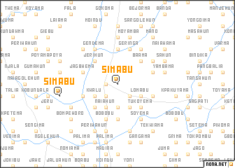
Simabu (Eastern, Sierra Leone)Simabu is a town in the Eastern region of Sierra Leone. An overview map of the region around Simabu is displayed below.
regional and 3d topo map of Simabu, Sierra Leone ::
Simabu airports ::
The nearest airport is FNA - Freetown Lungi, located 212.4 km west of Simabu.
Other airports nearby include FAA - Faranah (213.5 km north), MLW - Monrovia Spriggs Payne (218.4 km south), ROB - Monrovia Roberts Intl (240.0 km south east), Nearby towns ::
Boajibu (1.8km west) //
Mamboma (1.9km north) //
Legbela (2.6km south west) //
Bunjema (2.6km south east) //
Gandorhun (3.7km south) //
Kwalu (4.1km south west) //
Naiahun (4.1km south west) //
Komende (4.1km south west) //
Batoma (4.1km south east) //
Lomabu (4.1km south east) //
Bohun (5.2km south west) //
Tukoyema (5.2km south east) //
Jerihun (5.2km north west) //
Baama (5.2km north east) //
Berebu (5.6km south) //
Naiagolehun (5.6km north) //
Bawahun (5.6km north) //
Bobobu (5.9km south) //
Bunjema (5.8km west) //
Goma (5.8km east) //
Jagbwema (5.8km west) //
Guabu (5.8km east) //
Geringa (5.9km north) //
Gendema (6.7km north west) //
Garwama (6.7km north west) //
Soyema (6.7km south east) //
Naiyama (6.6km north east) //
Funima (6.7km north east) //
Bendu (7.3km west) //
[all distances 'as the bird flies' and approximate] 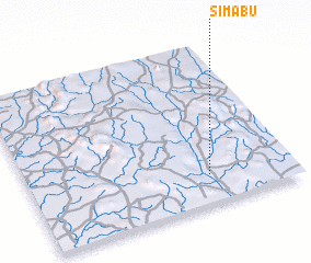 Places with similar names to Simabu, Sierra Leone ::
Disclaimer :: Information on this page comes without warranty of any kind |
||
|
Where is Simabu? Elevation and coordinates ::
Latitude (lat): 8°11'0"N Longitude (lon): 11°19'0"W
Elevation (approx.): 153m (map arrows pan, magnifying glasses zoom) |
||
|
Visiting Simabu? Hotel/Accommodation ::
Book a hotel in Simabu Travel Guide ::
rental cars ::
car rental offers GPS waypoint ::
download a GPX waypoint (PoI) of Simabu for your GPS receiver
|
||