|
search place name
|
||
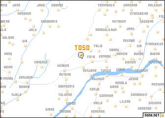
Toso (Eastern, Sierra Leone)Toso is a town in the Eastern region of Sierra Leone. An overview map of the region around Toso is displayed below.
regional and 3d topo map of Toso, Sierra Leone ::
Toso airports ::
The nearest airport is MLW - Monrovia Spriggs Payne, located 183.3 km south of Toso.
Other airports nearby include ROB - Monrovia Roberts Intl (203.8 km south east), Nearby towns ::
Kombema (2.0km south) //
Foya (2.2km east) //
Bomboima (2.6km north east) //
Kenjama (4.1km south east) //
Talia (4.1km north east) //
Hangha (4.7km north) //
Kenema (4.9km south west) //
Konabu (5.2km east) //
Gbandorma (5.9km north) //
Yabaima (5.8km east) //
Petema (6.0km south west) //
Tungie (6.6km south east) //
Majihun (6.7km south east) //
Gbaru (7.5km east) //
Sami (7.7km north east) //
Naiagolehun (7.8km north east) //
Gbenderu (8.1km south west) //
Konjo (8.5km south) //
Gidani (9.2km north west) //
Gelahun (9.2km north east) //
Konia (9.4km east) //
Kagbwama (10.4km north west) //
Siama (10.4km south east) //
Tinehun (10.7km north west) //
Putahun (11.3km north east) //
[all distances 'as the bird flies' and approximate] 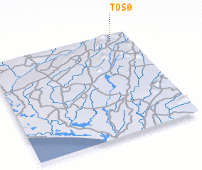 Places with similar names to Toso, Sierra Leone ::
Disclaimer :: Information on this page comes without warranty of any kind |
||
|
Where is Toso? Elevation and coordinates ::
Latitude (lat): 7°54'0"N Longitude (lon): 11°9'0"W
Elevation (approx.): 156m (map arrows pan, magnifying glasses zoom) |
||
|
Visiting Toso? Hotel/Accommodation ::
Book a hotel in Toso Travel Guide ::
rental cars ::
car rental offers GPS waypoint ::
download a GPX waypoint (PoI) of Toso for your GPS receiver
|
||