|
search place name
|
||
Nanako ((( Aoba/Maéwo )), Vanuatu)Nanako is a town in the (( Aoba/Maéwo )) region of Vanuatu. An overview map of the region around Nanako is displayed below.
regional and 3d topo map of Nanako, Vanuatu ::
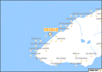
Nearby towns ::
Navitora (0.0km north) //
Navouti (0.0km north) //
Vatorousin (0.0km north) //
Longwarou (0.0km north) //
Londwa (1.9km north) //
Matandan (1.8km west) //
Natalou (1.9km south) //
Lobanga (1.9km south) //
Nagataro (1.9km south) //
Lolopinawa (1.8km east) //
Lolokalato (1.8km east) //
Loné (2.6km north east) //
Lounékoukwéou (2.6km north east) //
Nabagaaki (2.6km north east) //
Nagwingwim (2.6km south east) //
Amata (4.0km south west) //
Lolotingé (4.0km north east) //
Saranamoundou (4.0km north east) //
Tavala (4.1km south west) //
Ndui Ndui (4.0km south east) //
Saranatogoro (5.1km north east) //
Apopo (5.8km south) //
Masalato (5.7km west) //
Vatoukampani (6.5km north east) //
Longwarou (6.5km north east) //
Lonwaditari (6.5km north east) //
Vilakalaka (6.5km south west) //
Navoutouriki (7.7km south west) //
Fingalato (8.1km north east) //
[all distances 'as the bird flies' and approximate] 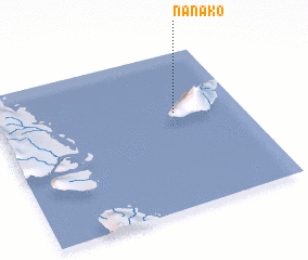 Places with similar names to Nanako, Vanuatu ::
Disclaimer :: Information on this page comes without warranty of any kind |
||
|
Where is Nanako? Elevation and coordinates ::
Latitude (lat): 15°23'0"S Longitude (lon): 167°44'0"E
Elevation (approx.): 106m (map arrows pan, magnifying glasses zoom) |
||
|
Visiting Nanako? Hotel/Accommodation ::
Book a hotel in Nanako Travel Guide ::
Buy a travel guide for Vanuatu rental cars ::
car rental offers GPS waypoint ::
download a GPX waypoint (PoI) of Nanako for your GPS receiver
|
||