|
search place name
|
||
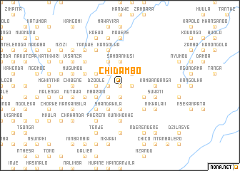
Chidambo (Malawi)Chidambo is a town in Malawi. An overview map of the region around Chidambo is displayed below.
regional and 3d topo map of Chidambo, Malawi ::
Chidambo airports ::
The nearest airport is LLW - Lilongwe Kamuzu Intl, located 50.0 km south west of Chidambo.
Other airports nearby include VXC - Lichinga (139.5 km east), ZZU - Mzuzu (214.5 km north), Nearby towns ::
Nyanga (0.0km north) //
Masache (1.8km west) //
Ngombe (1.9km south) //
Mpamila (1.8km east) //
Magayisa (2.6km north west) //
Mchere (2.6km north west) //
Mtongo (2.6km south west) //
Ntchisi (2.6km north east) //
Dzoole (3.6km west) //
Mguruwe (3.7km north) //
Sambankusi (3.7km north) //
Mphande (3.7km north) //
Nthukwa (3.7km south) //
Chiriwiya (3.7km south) //
Kwera (4.1km north west) //
Kanyerere (4.1km north west) //
Mkwichi (4.1km north west) //
Moto (4.1km north west) //
Mbarami (4.1km south west) //
Shandawila (4.1km south west) //
Chimbalanga (4.1km south east) //
Chilopola (5.2km south west) //
Mpundu (5.2km south west) //
Chimponda (5.2km south east) //
Kunkhokwe (5.6km south) //
Kambanbanga (5.4km east) //
Chikwakwa (5.7km west) //
Kangolwa (5.8km north) //
Chinkande (5.7km west) //
[all distances 'as the bird flies' and approximate]  Places with similar names to Chidambo, Malawi ::
Disclaimer :: Information on this page comes without warranty of any kind |
||
|
Where is Chidambo? Elevation and coordinates ::
Latitude (lat): 13°23'0"S Longitude (lon): 33°59'0"E
Elevation (approx.): 1390m (map arrows pan, magnifying glasses zoom) |
||
|
Visiting Chidambo? Hotel/Accommodation ::
Book a hotel in Chidambo Travel Guide ::
Buy a travel guide for Malawi rental cars ::
car rental offers GPS waypoint ::
download a GPX waypoint (PoI) of Chidambo for your GPS receiver
|
||