|
search place name
|
||
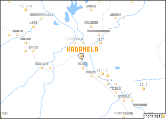
Kadamela (Malawi)Kadamela is a town in Malawi. An overview map of the region around Kadamela is displayed below.
regional and 3d topo map of Kadamela, Malawi ::
Kadamela airports ::
The nearest airport is BLZ - Blantyre Chileka Intl, located 101.5 km north of Kadamela.
Other airports nearby include TET - Tete Chingodzi (168.1 km west), UEL - Quelimane (232.2 km south east), Nearby towns ::
Ncaca (1.9km south) //
Chiromo (3.7km north) //
Nchenyela (4.1km north west) //
Mpisamanja (4.1km north west) //
Maere (4.1km south east) //
Cinsomba (4.1km south east) //
Jonasi (4.1km south east) //
Chilomo (4.2km north east) //
Mʼnembe (5.1km south east) //
Nyapambere (5.1km south east) //
Mʼtoa (5.3km north east) //
Afonso (5.4km south east) //
Mwanabvumbwe (6.6km north east) //
Vicente (6.5km south east) //
Nanthana (7.3km west) //
Kalonga (7.6km north) //
Ncaca (7.7km south east) //
Dzongua (9.0km south east) //
Tizola (10.3km south east) //
[all distances 'as the bird flies' and approximate]  Places with similar names to Kadamela, Malawi ::
// Goodmill (US)
// Guadamello (IT)
// Gądów Mały (PL)
// Guty Małe (PL)
// Gwda Mała (PL)
// Kutemeli (RU)
// Godéambolè (CF)
// Kadamalia (TD)
// Cotomal (CO)
// Kadimbula (CD)
Disclaimer :: Information on this page comes without warranty of any kind |
||
|
Where is Kadamela? Elevation and coordinates ::
Latitude (lat): 16°35'0"S Longitude (lon): 35°8'0"E
Elevation (approx.): 43m (map arrows pan, magnifying glasses zoom) |
||
|
Visiting Kadamela? Hotel/Accommodation ::
Book a hotel in Kadamela Travel Guide ::
Buy a travel guide for Malawi rental cars ::
car rental offers GPS waypoint ::
download a GPX waypoint (PoI) of Kadamela for your GPS receiver
|
||