|
search place name
|
||
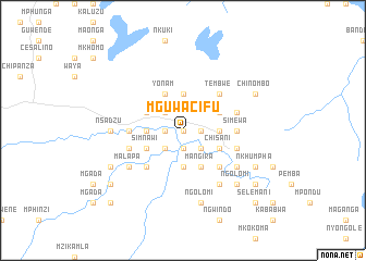
Mguwacifu (Malawi)Mguwacifu is a town in Malawi. An overview map of the region around Mguwacifu is displayed below.
regional and 3d topo map of Mguwacifu, Malawi ::
Mguwacifu airports ::
The nearest airport is LLW - Lilongwe Kamuzu Intl, located 68.8 km west of Mguwacifu.
Other airports nearby include VXC - Lichinga (106.9 km north east), BLZ - Blantyre Chileka Intl (219.9 km south), Nearby towns ::
Bibi (0.0km north) //
Mambo (0.0km north) //
Katambo (0.0km north) //
Msuta (0.0km north) //
Bingo (0.0km north) //
Kunchakama (1.9km south) //
Kawanga (1.8km east) //
Mwanzawala (1.9km south) //
Chemlima (1.8km west) //
Namacete (1.8km west) //
Katawa (1.8km west) //
Liganga (2.6km south east) //
Chimbalanga (2.6km south east) //
Kawanga (2.6km south east) //
Salima (2.6km south east) //
Chisamba (2.6km south west) //
Mangila (2.6km south west) //
Kambwili (2.6km north west) //
Kambwiri (3.7km south) //
Karonga (3.6km east) //
Kudana (3.6km east) //
Tsoyo (3.7km north) //
Mwengelele (3.6km west) //
Kaphathenga (3.6km west) //
Mlimagwengwe (3.6km west) //
Mangira (4.1km south east) //
Chisani (4.0km south east) //
Kamphido (4.0km north east) //
Simnawi (4.0km south west) //
[all distances 'as the bird flies' and approximate]  Places with similar names to Mguwacifu, Malawi :: Disclaimer :: Information on this page comes without warranty of any kind |
||
|
Where is Mguwacifu? Elevation and coordinates ::
Latitude (lat): 13°46'0"S Longitude (lon): 34°25'0"E
Elevation (approx.): 519m (map arrows pan, magnifying glasses zoom) |
||
|
Visiting Mguwacifu? Hotel/Accommodation ::
Book a hotel in Mguwacifu Travel Guide ::
Buy a travel guide for Malawi rental cars ::
car rental offers GPS waypoint ::
download a GPX waypoint (PoI) of Mguwacifu for your GPS receiver
|
||