|
search place name
|
||
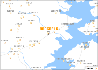
Bongofla (Cote d'Ivoire)Bongofla is a town in Cote d'Ivoire. An overview map of the region around Bongofla is displayed below.
regional and 3d topo map of Bongofla, Cote d'Ivoire ::
Bongofla airports ::
The nearest airport is BYK - Bouake, located 80.8 km east of Bongofla.
Other airports nearby include ASK - Yamoussoukro (84.6 km south east), DJO - Daloa (113.1 km south west), MJC - Man (201.8 km west), HGO - Korhogo (205.1 km north), Nearby towns ::
Gouzanfla (2.3km north east) //
Brodoufla (5.0km south west) //
Iriétafla (6.7km south west) //
Ouréitafla (6.9km south west) //
Diabouéfla (7.8km south west) //
Grobonou Dan (7.9km north east) //
Bouedianfla (8.1km south west) //
Gonfla (8.3km north west) //
Bouayakro (8.8km north) //
Oueproye (8.8km south west) //
Gooufla (9.4km north west) //
Gounéfla (9.8km north west) //
[all distances 'as the bird flies' and approximate] 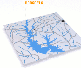 Places with similar names to Bongofla, Cote d'Ivoire ::
// Bang Phli (TH)
// Bingville (US)
// Bangui Ville (CF)
// Binga-Vula (CD)
// Biancavilla (IT)
// Bunkeflo (SE)
// Bangofla (CI)
Disclaimer :: Information on this page comes without warranty of any kind |
||
|
Where is Bongofla? Elevation and coordinates ::
Latitude (lat): 7°32'47"N Longitude (lon): 5°46'50"W
Elevation (approx.): 265m (map arrows pan, magnifying glasses zoom) |
||
|
Visiting Bongofla? Hotel/Accommodation ::
Book a hotel in Bongofla Travel Guide ::
rental cars ::
car rental offers GPS waypoint ::
download a GPX waypoint (PoI) of Bongofla for your GPS receiver
|
||