|
search place name
|
||
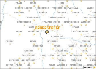
Nangasèrègè (Cote d'Ivoire)Nangasèrègè is a town in Cote d'Ivoire. An overview map of the region around Nangasèrègè is displayed below.
regional and 3d topo map of Nangasèrègè, Cote d'Ivoire ::
Nangasèrègè airports ::
The nearest airport is HGO - Korhogo, located 22.1 km south east of Nangasèrègè.
Other airports nearby include BYK - Bouake (206.2 km south), BOY - Bobo-dioulasso Bobo Dioulasso (240.8 km north east), Nearby towns ::
Fononfila (1.9km north) //
Blawara (2.6km north east) //
Dih (2.6km north west) //
Nanyènengèkaha (3.7km east) //
Tyélivogo (3.7km north) //
Nyanbélégé (4.1km south east) //
Katoumara (4.1km south east) //
Gbaloho (4.1km north east) //
Yéfon (5.2km north east) //
Sammbokaha (5.5km west) //
Kanyènékaha (5.9km south) //
Syonkolo (5.8km west) //
Pinyon (6.6km south west) //
Natyo Kabadara (6.7km north east) //
Kapélé (6.7km south east) //
Séllé (6.6km north east) //
Katanvogo (6.7km south west) //
Nonfoun (7.6km north) //
Doromanivogo (7.8km north west) //
Naporomakaha (8.3km south east) //
Zongotakaha (9.2km south east) //
Lofiné (9.2km north east) //
Plouvogo (9.2km north east) //
Waranyéné (10.4km south east) //
Korokaha (10.4km south west) //
[all distances 'as the bird flies' and approximate] 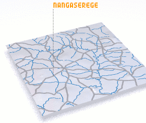 Places with similar names to Nangasèrègè, Cote d'Ivoire :: Disclaimer :: Information on this page comes without warranty of any kind |
||
|
Where is Nangasèrègè? Elevation and coordinates ::
Latitude (lat): 9°29'0"N Longitude (lon): 5°44'0"W
Elevation (approx.): 371m (map arrows pan, magnifying glasses zoom) |
||
|
Visiting Nangasèrègè? Hotel/Accommodation ::
Book a hotel in Nangasèrègè Travel Guide ::
rental cars ::
car rental offers GPS waypoint ::
download a GPX waypoint (PoI) of Nangasèrègè for your GPS receiver
|
||