|
search place name
|
||
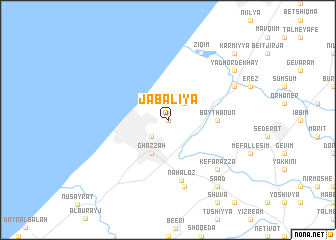
Jabāliyā (Palestinian Territory)Jabāliyā is a town in Palestinian Territory. An overview map of the region around Jabāliyā is displayed below.
regional and 3d topo map of Jabāliyā, Palestinian Territory ::
Jabāliyā airports ::
The nearest airport is BEV - Beer-sheba Teyman, located 35.6 km south east of Jabāliyā.
Other airports nearby include TLV - Tel-aviv Ben Gurion (65.3 km north east), SDV - Tel-aviv Sde Dov (70.4 km north east), AMM - Amman Queen Alia Intl (144.8 km east), ADJ - Amman Marka Intl (151.0 km east), Nearby towns ::
An Nazlah (0.0km north) //
Al Mashāhirah (2.4km south west) //
Saknat az Zarqāʼ (2.4km south west) //
Bayt Lāhiyah (2.4km north east) //
Ghazzah (4.0km south west) //
Bayt Ḩānūn (4.7km east) //
Naẖal ‘Oz (6.9km south) //
Beʼerot Yiẕẖaq (7.6km south) //
Kefar ‘Azza (7.3km south east) //
Deir Suneid (7.3km north east) //
Ziqim (8.1km north east) //
Sa‘ad (8.8km south east) //
Yad Mordekhay (8.4km north east) //
Karmiyya (9.7km north east) //
[all distances 'as the bird flies' and approximate] 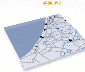
Disclaimer :: Information on this page comes without warranty of any kind |
||
|
Where is Jabāliyā? Elevation and coordinates ::
Latitude (lat): 31°32'0"N Longitude (lon): 34°29'0"E
Elevation (approx.): 39m (map arrows pan, magnifying glasses zoom) |
||
|
Visiting Jabāliyā? Hotel/Accommodation ::
Book a hotel in Jabāliyā Travel Guide ::
rental cars ::
car rental offers GPS waypoint ::
download a GPX waypoint (PoI) of Jabāliyā for your GPS receiver
|
||