|
search place name
|
||
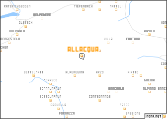
AllʼAcqua (Aargau, Switzerland)AllʼAcqua is a town in the Aargau region of Switzerland. An overview map of the region around AllʼAcqua is displayed below.
regional and 3d topo map of AllʼAcqua, Switzerland ::
AllʼAcqua airports ::
The nearest airport is LUG - Lugano, located 63.3 km south east of AllʼAcqua.
Other airports nearby include BRN - Bern Belp (88.3 km north west), SIR - Sion (92.5 km west), MXP - Milano Malpensa (96.9 km south), SMV - Samedan (108.9 km east), Nearby towns ::
Alpe Regina (3.9km south) //
Bedretto (3.2km north east) //
Ronco (3.2km north east) //
Arzo (4.5km south east) //
Villa (5.3km north east) //
Riale (8.3km south west) //
Campo (8.3km south east) //
Morasco (7.5km south west) //
San Carlo (9.0km south east) //
Sopra la Frua (9.0km south west) //
[all distances 'as the bird flies' and approximate] 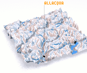 Places with similar names to AllʼAcqua, Switzerland ::
Disclaimer :: Information on this page comes without warranty of any kind |
||
|
Where is AllʼAcqua? Elevation and coordinates ::
Latitude (lat): 46°29'0"N Longitude (lon): 8°28'0"E
Elevation (approx.): 1670m (map arrows pan, magnifying glasses zoom) |
||
|
Visiting AllʼAcqua? Hotel/Accommodation ::
Book a hotel in AllʼAcqua Travel Guide ::
Buy a travel guide for Switzerland rental cars ::
car rental offers GPS waypoint ::
download a GPX waypoint (PoI) of AllʼAcqua for your GPS receiver
|
||