|
search place name
|
||
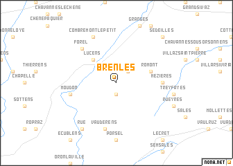
Brenles (Aargau, Switzerland)Brenles is a town in the Aargau region of Switzerland. An overview map of the region around Brenles is displayed below.
regional and 3d topo map of Brenles, Switzerland ::
Brenles airports ::
The nearest airport is BRN - Bern Belp, located 54.5 km north east of Brenles.
Other airports nearby include SIR - Sion (62.5 km south east), QNJ - Annemasse (71.4 km south west), GVA - Geneva Cointrin (76.4 km south west), NCY - Annecy Meythet (102.6 km south west), Nearby towns ::
Siviriez (1.9km south) //
Dompierre (2.2km north east) //
Lucens (4.5km north west) //
Romont (4.2km north east) //
Mézières (5.1km east) //
Vauderens (7.5km south) //
Moudon (5.4km west) //
Forel (6.7km north west) //
Cheiry (7.8km north) //
Combremont-le-Petit (7.8km north) //
Rue (8.3km south west) //
Sedeilles (9.0km north east) //
Châtonnaye (9.0km north east) //
[all distances 'as the bird flies' and approximate]  Places with similar names to Brenles, Switzerland ::
// Brünlas (DE)
// Brünlos (DE)
// Bernales (ES)
// Bernales (ES)
// Brañuelas (ES)
// Brown Ellis (US)
// Bernales (MX)
// Bernales (PE)
// Bernieulles (FR)
// Brennilis (FR)
Disclaimer :: Information on this page comes without warranty of any kind |
||
|
Where is Brenles? Elevation and coordinates ::
Latitude (lat): 46°41'0"N Longitude (lon): 6°52'0"E
Elevation (approx.): 776m (map arrows pan, magnifying glasses zoom) |
||
|
Visiting Brenles? Hotel/Accommodation ::
Book a hotel in Brenles Travel Guide ::
Buy a travel guide for Switzerland rental cars ::
car rental offers GPS waypoint ::
download a GPX waypoint (PoI) of Brenles for your GPS receiver
|
||