|
search place name
|
||
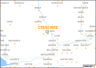
Cresciano (Aargau, Switzerland)Cresciano is a town in the Aargau region of Switzerland. An overview map of the region around Cresciano is displayed below.
regional and 3d topo map of Cresciano, Switzerland ::
Cresciano airports ::
The nearest airport is LUG - Lugano, located 30.0 km south of Cresciano.
Other airports nearby include MXP - Milano Malpensa (73.8 km south), SMV - Samedan (74.2 km north east), BGY - Bergamo Orio Al Serio (85.6 km south east), LIN - Milan Linate (93.8 km south), Nearby towns ::
Duno (1.3km east) //
Moleno (1.3km west) //
Prosito (2.3km north west) //
Claro (3.2km south east) //
Gnosca (3.9km south) //
Lodrino (4.5km north west) //
Castione (4.5km south east) //
Osogna (5.7km north) //
Gorduno (5.7km south) //
Iragna (6.1km north west) //
Bellinzona (7.5km south) //
Arbedo (8.4km south east) //
Lumino (7.6km south east) //
Tagliada (9.0km south east) //
[all distances 'as the bird flies' and approximate]  Places with similar names to Cresciano, Switzerland ::
// Christiana (US)
// Christian (US)
// Christiana (US)
// Groß-Eichen (DE)
// Crasciana (IT)
// Grisciano (IT)
// Grzechynia (PL)
// Cristian (RO)
// Cristian (RO)
// Krasichin (UA)
Disclaimer :: Information on this page comes without warranty of any kind |
||
|
Where is Cresciano? Elevation and coordinates ::
Latitude (lat): 46°16'0"N Longitude (lon): 9°0'0"E
Elevation (approx.): 255m (map arrows pan, magnifying glasses zoom) |
||
|
Visiting Cresciano? Hotel/Accommodation ::
Book a hotel in Cresciano Travel Guide ::
Buy a travel guide for Switzerland rental cars ::
car rental offers GPS waypoint ::
download a GPX waypoint (PoI) of Cresciano for your GPS receiver
|
||