|
search place name
|
||
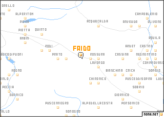
Faido (Aargau, Switzerland)Faido is a town in the Aargau region of Switzerland. An overview map of the region around Faido is displayed below.
regional and 3d topo map of Faido, Switzerland ::
Faido airports ::
The nearest airport is LUG - Lugano, located 52.1 km south of Faido.
Other airports nearby include SMV - Samedan (83.6 km east), MXP - Milano Malpensa (93.1 km south), BRN - Bern Belp (111.4 km north west), BGY - Bergamo Orio Al Serio (112.5 km south east), Nearby towns ::
Calpiogna (1.9km north) //
Chiggiogna (1.3km east) //
Gribbio (1.3km east) //
Croce (2.3km north east) //
Osco (2.3km north west) //
Rossura (2.6km east) //
Dalpe (2.6km west) //
Lavorgo (3.2km south east) //
Prato (3.8km west) //
Cala (5.7km south) //
Chironico (6.1km south east) //
Rodi (5.4km west) //
Acquacalda (7.8km north) //
Biaschina (6.3km south east) //
Angone (6.3km south east) //
[all distances 'as the bird flies' and approximate] 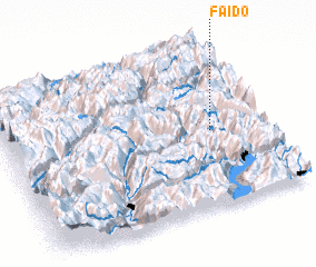 Places with similar names to Faido, Switzerland ::
Disclaimer :: Information on this page comes without warranty of any kind |
||
|
Where is Faido? Elevation and coordinates ::
Latitude (lat): 46°28'0"N Longitude (lon): 8°48'0"E
Elevation (approx.): 1183m (map arrows pan, magnifying glasses zoom) |
||
|
Visiting Faido? Hotel/Accommodation ::
Book a hotel in Faido Travel Guide ::
Buy a travel guide for Switzerland rental cars ::
car rental offers GPS waypoint ::
download a GPX waypoint (PoI) of Faido for your GPS receiver
|
||