|
search place name
|
||
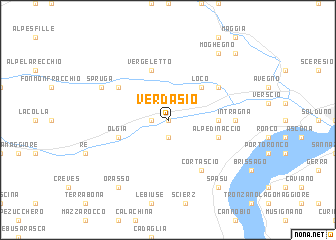
Verdasio (Aargau, Switzerland)Verdasio is a town in the Aargau region of Switzerland. An overview map of the region around Verdasio is displayed below.
regional and 3d topo map of Verdasio, Switzerland ::
Verdasio airports ::
The nearest airport is LUG - Lugano, located 28.0 km south east of Verdasio.
Other airports nearby include MXP - Milano Malpensa (60.0 km south), LIN - Milan Linate (94.5 km south east), BGY - Bergamo Orio Al Serio (99.5 km south east), SIR - Sion (101.0 km west), Nearby towns ::
Borgnone (0.0km north) //
Mosogno (1.9km north) //
Camedo (1.3km west) //
Palagnedra (1.9km south) //
Loco (4.5km north east) //
Corcapolo (3.9km east) //
Vergeletto (5.7km north) //
Crana (5.7km north) //
Gresso (5.7km north) //
Alpe di Naccio (4.3km south east) //
Olgia (4.3km south west) //
Auressio (5.3km north east) //
Comologno (5.3km north west) //
Cortascio (6.1km south east) //
Intragna (5.1km east) //
Spruga (6.3km north west) //
Moghegno (8.4km north east) //
Spasu (8.4km south east) //
Orasso (8.4km south west) //
Aurigeno (9.0km north east) //
[all distances 'as the bird flies' and approximate] 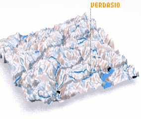 Places with similar names to Verdasio, Switzerland ::
Disclaimer :: Information on this page comes without warranty of any kind |
||
|
Where is Verdasio? Elevation and coordinates ::
Latitude (lat): 46°10'0"N Longitude (lon): 8°38'0"E
Elevation (approx.): 687m (map arrows pan, magnifying glasses zoom) |
||
|
Visiting Verdasio? Hotel/Accommodation ::
Book a hotel in Verdasio Travel Guide ::
Buy a travel guide for Switzerland rental cars ::
car rental offers GPS waypoint ::
download a GPX waypoint (PoI) of Verdasio for your GPS receiver
|
||