|
search place name
|
||
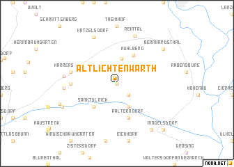
Altlichtenwarth (Niederösterreich, Austria)Altlichtenwarth is a town in the Niederösterreich region of Austria. An overview map of the region around Altlichtenwarth is displayed below.
regional and 3d topo map of Altlichtenwarth, Austria ::
Altlichtenwarth airports ::
The nearest airport is BRQ - Turany, located 58.1 km north of Altlichtenwarth.
Other airports nearby include BTS - Bratislava M R Stefanik (59.9 km south east), VIE - Vienna Schwechat (60.6 km south), PZY - Piestany (75.8 km east), PRV - Prerov (98.6 km north east), Nearby towns ::
Neusiedl an der Zaya (0.0km north) //
Hausbrunn (2.2km south east) //
Mühlberg (4.0km north) //
Dobermannsdorf (3.9km south) //
Sankt Ulrich (4.4km south west) //
Hauskirchen (4.4km south west) //
Mühlberg (4.9km north) //
Palterndorf (5.7km south) //
Althöflein (4.9km west) //
Harrersdorf (5.2km west) //
Reintal (7.8km north) //
Katzelsdorf (7.8km north) //
Großkrut (5.7km west) //
Ginzersdorf (5.7km west) //
Niederabsdorf (8.3km south east) //
Bernhardsthal (7.4km north east) //
Prinzendorf an der Zaya (6.9km south west) //
Ringelsdorf (8.9km south east) //
[all distances 'as the bird flies' and approximate] 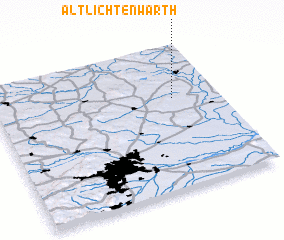 Places with similar names to Altlichtenwarth, Austria :: Disclaimer :: Information on this page comes without warranty of any kind |
||
|
Where is Altlichtenwarth? Elevation and coordinates ::
Latitude (lat): 48°38'0"N Longitude (lon): 16°48'0"E
Elevation (approx.): 215m (map arrows pan, magnifying glasses zoom) |
||
|
Visiting Altlichtenwarth? Hotel/Accommodation ::
Book a hotel in Altlichtenwarth Travel Guide ::
Buy a travel guide for Austria rental cars ::
car rental offers GPS waypoint ::
download a GPX waypoint (PoI) of Altlichtenwarth for your GPS receiver
|
||