|
search place name
|
||
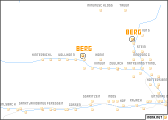
Berg (Tirol, Austria)Berg is a town in the Tirol region of Austria. An overview map of the region around Berg is displayed below.
regional and 3d topo map of Berg, Austria ::
Berg airports ::
The nearest airport is INN - Innsbruck, located 85.8 km west of Berg.
Other airports nearby include SZG - Salzburg (97.1 km north east), BZO - Bolzano (103.8 km south west), AVB - Aviano Ab (Pagliano E Gori) (110.3 km south), OBF - Oberpfaffenhofen (145.9 km north west), Nearby towns ::
Stein (0.0km north) //
Bobojach (1.3km west) //
Welzelach (1.9km south) //
Obermauern (2.2km south east) //
Marin (2.5km east) //
Wallhorn (2.5km west) //
Prägraten (2.5km west) //
Virgen (3.1km south east) //
Göriach (3.1km south east) //
Niedermauern (3.1km south east) //
Oberbichl (3.8km west) //
Losach (3.8km west) //
Bichl (3.8km west) //
Mellitz (4.2km south east) //
Feldner (5.1km west) //
Bach (5.4km east) //
Zedlach (5.4km east) //
Mitteldorf (5.5km east) //
[all distances 'as the bird flies' and approximate] 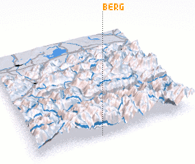 Places with similar names to Berg, Austria ::
Disclaimer :: Information on this page comes without warranty of any kind |
||
|
Where is Berg? Elevation and coordinates ::
Latitude (lat): 47°1'0"N Longitude (lon): 12°25'0"E
Elevation (approx.): 1554m (map arrows pan, magnifying glasses zoom) |
||
|
Visiting Berg? Hotel/Accommodation ::
Book a hotel in Berg Travel Guide ::
Buy a travel guide for Austria rental cars ::
car rental offers GPS waypoint ::
download a GPX waypoint (PoI) of Berg for your GPS receiver
|
||