|
search place name
|
||
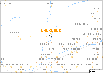
Gwercher (Tirol, Austria)Gwercher is a town in the Tirol region of Austria. An overview map of the region around Gwercher is displayed below.
regional and 3d topo map of Gwercher, Austria ::
Gwercher airports ::
The nearest airport is INN - Innsbruck, located 50.7 km south west of Gwercher.
Other airports nearby include OBF - Oberpfaffenhofen (78.0 km north west), SZG - Salzburg (88.5 km east), FEL - Fuerstenfeldbruck Furstenfeldbruck (90.1 km north west), MUC - Munich Munchen (93.5 km north), Nearby towns ::
Aschau (1.3km west) //
Hub (1.9km south) //
Kaiserhaus (2.2km north east) //
Stegen (2.2km south west) //
Eben (3.7km south) //
Markstein (3.9km south) //
Brandenberg (3.9km south) //
Haus (4.5km south east) //
Mosen (5.6km south) //
Hinterberg (5.0km west) //
Voldöpp (7.5km south) //
Radfeld (7.5km south) //
Außersteinberg (5.5km west) //
Achenrain (7.8km south) //
Kramsach (7.8km south) //
Mariatal (7.8km south) //
Breitenbach am Inn (6.2km south east) //
Ramsau (6.2km south east) //
Sankt Leonhard (7.5km south east) //
Saulueg (8.9km south east) //
[all distances 'as the bird flies' and approximate] 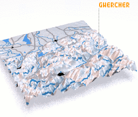 Places with similar names to Gwercher, Austria :: Disclaimer :: Information on this page comes without warranty of any kind |
||
|
Where is Gwercher? Elevation and coordinates ::
Latitude (lat): 47°31'0"N Longitude (lon): 11°54'0"E
Elevation (approx.): 778m (map arrows pan, magnifying glasses zoom) |
||
|
Visiting Gwercher? Hotel/Accommodation ::
Book a hotel in Gwercher Travel Guide ::
Buy a travel guide for Austria rental cars ::
car rental offers GPS waypoint ::
download a GPX waypoint (PoI) of Gwercher for your GPS receiver
|
||