|
search place name
|
||
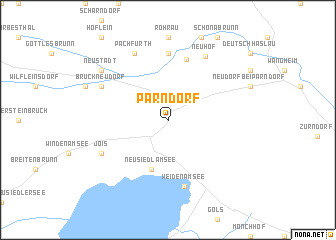
Parndorf (Burgenland, Austria)Parndorf is a town in the Burgenland region of Austria. An overview map of the region around Parndorf is displayed below.
regional and 3d topo map of Parndorf, Austria ::
nearby GPS traces from timatio ::
Parndorf airports ::
The nearest airport is VIE - Vienna Schwechat, located 25.2 km north west of Parndorf.
Other airports nearby include BTS - Bratislava M R Stefanik (34.1 km north east), PZY - Piestany (101.8 km north east), BRQ - Turany (130.4 km north), GRZ - Graz (153.2 km south west), Nearby towns ::
Neusiedl am See (5.7km south) //
Alter Futterplatz (6.9km north) //
Gerhaus (7.4km north) //
Weiden am See (7.5km south) //
Neuhof (7.6km north) //
Pachfurth (7.8km north) //
Jois (6.2km south west) //
Bruckneudorf (6.2km north west) //
Neustadt (7.5km north west) //
[all distances 'as the bird flies' and approximate] 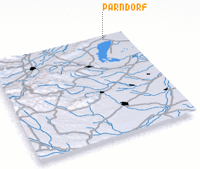 Places with similar names to Parndorf, Austria ::
Disclaimer :: Information on this page comes without warranty of any kind |
||
|
Where is Parndorf? Elevation and coordinates ::
Latitude (lat): 47°59'0"N Longitude (lon): 16°51'0"E
Elevation (approx.): 180m (map arrows pan, magnifying glasses zoom) |
||
|
Visiting Parndorf? Hotel/Accommodation ::
Book a hotel in Parndorf Travel Guide ::
Buy a travel guide for Austria rental cars ::
car rental offers GPS waypoint ::
download a GPX waypoint (PoI) of Parndorf for your GPS receiver
|
||