|
search place name
|
||
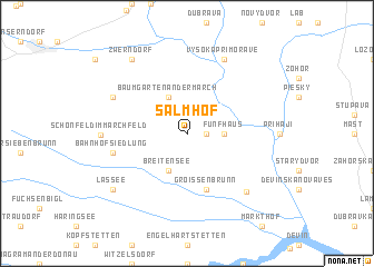
Salmhof (Niederösterreich, Austria)Salmhof is a town in the Niederösterreich region of Austria. An overview map of the region around Salmhof is displayed below.
regional and 3d topo map of Salmhof, Austria ::
nearby GPS traces from timatio ::
Salmhof airports ::
The nearest airport is BTS - Bratislava M R Stefanik, located 26.7 km south east of Salmhof.
Other airports nearby include VIE - Vienna Schwechat (29.1 km south west), PZY - Piestany (80.5 km north east), BRQ - Turany (99.3 km north), PRV - Prerov (134.5 km north), Nearby towns ::
Marchegg (1.2km east) //
Fünfhaus (2.5km east) //
Baumgarten an der March (3.9km north) //
Breitensee (3.9km south) //
Groißenbrunn (5.7km south) //
Bahnhofsiedlung (5.3km west) //
Schloßhof (7.0km south east) //
Oberweiden (6.2km north west) //
Vysoká pri Morave (7.8km north) //
Schönfeld im Marchfeld (5.8km west) //
Zwerndorf (8.3km north west) //
Lassee (7.4km south west) //
[all distances 'as the bird flies' and approximate] 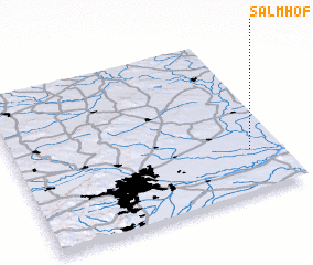 Places with similar names to Salmhof, Austria :: Disclaimer :: Information on this page comes without warranty of any kind |
||
|
Where is Salmhof? Elevation and coordinates ::
Latitude (lat): 48°16'0"N Longitude (lon): 16°53'0"E
Elevation (approx.): 148m (map arrows pan, magnifying glasses zoom) |
||
|
Visiting Salmhof? Hotel/Accommodation ::
Book a hotel in Salmhof Travel Guide ::
Buy a travel guide for Austria rental cars ::
car rental offers GPS waypoint ::
download a GPX waypoint (PoI) of Salmhof for your GPS receiver
|
||