|
search place name
|
||
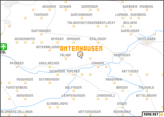
Amtenhausen (Baden-Württemberg, Germany)Amtenhausen is a town in the Baden-Württemberg region of Germany. An overview map of the region around Amtenhausen is displayed below.
regional and 3d topo map of Amtenhausen, Germany ::
Amtenhausen airports ::
The nearest airport is ZQL - Donaueschingen Villingen, located 12.3 km west of Amtenhausen.
Other airports nearby include ZRH - Zurich (54.9 km south), FDH - Friedrichshafen (69.3 km south east), ACH - St Gallen Altenrhein (83.7 km south east), STR - Stuttgart (91.5 km north east), Nearby towns ::
Bachzimmern (1.2km east) //
Talhof (2.5km west) //
Hausen (3.7km south) //
Ippingen (3.9km north) //
Kirchen (3.9km south) //
Hintschingen (3.9km south) //
Zimmern (3.1km south east) //
Eßlingen (4.5km north east) //
Immendingen (4.2km south east) //
Öfingen (5.3km north west) //
Geisingen (5.3km south west) //
Unterbaldingen (5.3km west) //
Dreilärchen (5.3km west) //
Talheim (7.5km north) //
Aulfingen (7.5km south) //
Kirchberg (7.8km north) //
Oberflacht (7.8km north) //
Seitingen-Oberflacht (7.8km north) //
Gutmadingen (7.5km south west) //
Seitingen (8.3km north east) //
Mauenheim (7.5km south east) //
[all distances 'as the bird flies' and approximate] 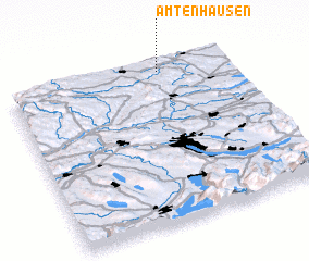 Places with similar names to Amtenhausen, Germany :: Disclaimer :: Information on this page comes without warranty of any kind |
||
|
Where is Amtenhausen? Elevation and coordinates ::
Latitude (lat): 47°57'0"N Longitude (lon): 8°41'0"E
Elevation (approx.): 834m (map arrows pan, magnifying glasses zoom) |
||
|
Visiting Amtenhausen? Hotel/Accommodation ::
Book a hotel in Amtenhausen Travel Guide ::
Buy a travel guide for Germany rental cars ::
car rental offers GPS waypoint ::
download a GPX waypoint (PoI) of Amtenhausen for your GPS receiver
|
||