|
search place name
|
||
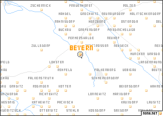
Beyern (Brandenburg, Germany)Beyern is a town in the Brandenburg region of Germany. An overview map of the region around Beyern is displayed below.
regional and 3d topo map of Beyern, Germany ::
Beyern airports ::
The nearest airport is DRS - Dresden, located 66.8 km south east of Beyern.
Other airports nearby include LEJ - Leipzig Halle (69.6 km west), AOC - Altenburg Nobitz (85.6 km south west), SXF - Berlin Schonefeld (87.8 km north), THF - Berlin Tempelhof (96.3 km north), Nearby towns ::
Fermerswalde (3.7km north) //
Großrössen (3.0km north east) //
Kölsa (3.9km south) //
Rehfeld (4.4km south west) //
Gräfendorf (5.7km north) //
Löhsten (3.9km south west) //
Buckau (6.0km north) //
Falkenberg (5.1km south east) //
Bicking (7.5km north) //
Döbrichau (5.0km west) //
Schmerkendorf (6.5km south east) //
Rahnisdorf (7.8km north) //
Herzberg (7.8km north) //
Kleinrössen (5.9km north east) //
Neuhof (5.9km north east) //
Kötten (7.8km south) //
Elsterberg (8.2km south west) //
Friedersdorf (8.7km north east) //
Haidehäuser (8.7km south west) //
[all distances 'as the bird flies' and approximate] 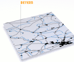 Places with similar names to Beyern, Germany ::
Disclaimer :: Information on this page comes without warranty of any kind |
||
|
Where is Beyern? Elevation and coordinates ::
Latitude (lat): 51°37'0"N Longitude (lon): 13°12'0"E
Elevation (approx.): 82m (map arrows pan, magnifying glasses zoom) |
||
|
Visiting Beyern? Hotel/Accommodation ::
Book a hotel in Beyern Travel Guide ::
Buy a travel guide for Germany rental cars ::
car rental offers GPS waypoint ::
download a GPX waypoint (PoI) of Beyern for your GPS receiver
|
||