|
search place name
|
||
Birgsau (Bayern, Germany)Birgsau is a town in the Bayern region of Germany. An overview map of the region around Birgsau is displayed below.
regional and 3d topo map of Birgsau, Germany ::

Birgsau airports ::
The nearest airport is ACH - St Gallen Altenrhein, located 55.9 km west of Birgsau.
Other airports nearby include FDH - Friedrichshafen (68.2 km north west), INN - Innsbruck (81.9 km east), SMV - Samedan (93.5 km south), OBF - Oberpfaffenhofen (112.8 km north east), Nearby towns ::
Einödsbach (1.9km south) //
Anatswald (1.9km north) //
Schwand (3.7km north) //
Ringang (3.7km north) //
Spielmannsau (3.1km north east) //
Dietersberg (6.1km north east) //
Gerstruben (5.3km north east) //
Oberstdorf (7.5km north) //
Kornau (7.5km north) //
Westegg (6.2km north west) //
Oib (7.8km north) //
Unterwestegg (6.2km north west) //
Oberwestegg (6.2km north west) //
Ausserschwende (7.1km north west) //
Schwende (7.1km north west) //
Innerschwende (7.1km north west) //
Lechleiten (9.0km south west) //
[all distances 'as the bird flies' and approximate] 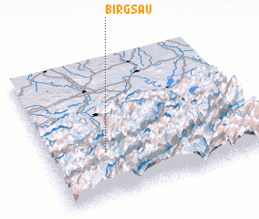 Places with similar names to Birgsau, Germany ::
Disclaimer :: Information on this page comes without warranty of any kind |
||
|
Where is Birgsau? Elevation and coordinates ::
Latitude (lat): 47°20'0"N Longitude (lon): 10°16'0"E
Elevation (approx.): 961m (map arrows pan, magnifying glasses zoom) |
||
|
Visiting Birgsau? Hotel/Accommodation ::
Book a hotel in Birgsau Travel Guide ::
Buy a travel guide for Germany rental cars ::
car rental offers GPS waypoint ::
download a GPX waypoint (PoI) of Birgsau for your GPS receiver
|
||