|
search place name
|
||
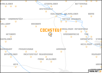
Cochstedt (Sachsen-Anhalt, Germany)Cochstedt is a town in the Sachsen-Anhalt region of Germany. An overview map of the region around Cochstedt is displayed below.
regional and 3d topo map of Cochstedt, Germany ::
Cochstedt airports ::
The nearest airport is LEJ - Leipzig Halle, located 76.0 km south east of Cochstedt.
Other airports nearby include BWE - Braunschweig Wolfsburg (76.3 km north west), ERF - Erfurt (105.5 km south), ZCN - Celle (123.6 km north west), AOC - Altenburg Nobitz (125.7 km south east), Nearby towns ::
Schneidlingen (3.9km north east) //
Winningen (6.0km south) //
Marienstuhl (6.0km north) //
Hakeborn (5.1km north west) //
Groß Börnecke (4.6km east) //
Neu Königsaue (7.5km south) //
Egeln (7.5km north) //
Egeln Nord (7.5km north) //
Schadeleben (6.5km south west) //
Tarthun (6.5km north east) //
Nachterstedt (8.7km south west) //
Wolmirsleben (8.7km north east) //
[all distances 'as the bird flies' and approximate] 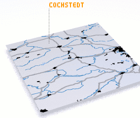 Places with similar names to Cochstedt, Germany ::
Disclaimer :: Information on this page comes without warranty of any kind |
||
|
Where is Cochstedt? Elevation and coordinates ::
Latitude (lat): 51°53'0"N Longitude (lon): 11°25'0"E
Elevation (approx.): 107m (map arrows pan, magnifying glasses zoom) |
||
|
Visiting Cochstedt? Hotel/Accommodation ::
Book a hotel in Cochstedt Travel Guide ::
Buy a travel guide for Germany rental cars ::
car rental offers GPS waypoint ::
download a GPX waypoint (PoI) of Cochstedt for your GPS receiver
|
||