|
search place name
|
||
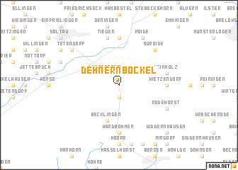
Dehnernbockel (Niedersachsen, Germany)Dehnernbockel is a town in the Niedersachsen region of Germany. An overview map of the region around Dehnernbockel is displayed below.
regional and 3d topo map of Dehnernbockel, Germany ::
Dehnernbockel airports ::
The nearest airport is ZCN - Celle, located 36.9 km south of Dehnernbockel.
Other airports nearby include HAJ - Hannover (53.1 km south), XFW - Hamburg Finkenwerder (69.1 km north), BRE - Bremen (77.3 km west), BWE - Braunschweig Wolfsburg (79.3 km south east), Nearby towns ::
Wroge (1.9km south) //
Lührsbockel (2.2km north west) //
Lehmberg (2.9km north west) //
Becklingen (5.7km south) //
Harber (7.4km north) //
Wietzendorf (4.5km east) //
Wardböhmen (7.4km south) //
Meinholz (4.8km north east) //
Tiegen (7.5km north) //
Suroide (6.5km north east) //
Moide (7.7km north) //
Rodehorst (5.8km south east) //
Marbostel (5.8km south east) //
Tetendorf (7.1km north west) //
Widdernhausen (8.7km south east) //
[all distances 'as the bird flies' and approximate] 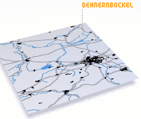 Places with similar names to Dehnernbockel, Germany :: Disclaimer :: Information on this page comes without warranty of any kind |
||
|
Where is Dehnernbockel? Elevation and coordinates ::
Latitude (lat): 52°55'0"N Longitude (lon): 9°55'0"E
Elevation (approx.): 76m (map arrows pan, magnifying glasses zoom) |
||
|
Visiting Dehnernbockel? Hotel/Accommodation ::
Book a hotel in Dehnernbockel Travel Guide ::
Buy a travel guide for Germany rental cars ::
car rental offers GPS waypoint ::
download a GPX waypoint (PoI) of Dehnernbockel for your GPS receiver
|
||