|
search place name
|
||
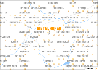
Dietelhofen (Baden-Württemberg, Germany)Dietelhofen is a town in the Baden-Württemberg region of Germany. An overview map of the region around Dietelhofen is displayed below.
regional and 3d topo map of Dietelhofen, Germany ::
Dietelhofen airports ::
The nearest airport is FDH - Friedrichshafen, located 57.1 km south of Dietelhofen.
Other airports nearby include STR - Stuttgart (61.8 km north west), ACH - St Gallen Altenrhein (77.6 km south), ZQL - Donaueschingen Villingen (81.3 km west), AGB - Augsburg (104.8 km east), Nearby towns ::
Uigendorf (1.2km east) //
Aderzhofen (1.9km south) //
Buchay (1.9km south) //
Reutlingendorf (1.9km north) //
Bussen (2.2km south west) //
Dobel (2.2km north east) //
Dietershausen (2.5km east) //
Offingen (3.7km south) //
Dentingen (3.7km south) //
Möhringen (2.5km west) //
Schupfenberg (3.1km north east) //
Göffingen (4.5km south west) //
Datthausen (4.5km north west) //
Brühlhof (5.6km north) //
Obermarchtal (5.6km north) //
Dieterskirch (3.7km east) //
Unlingen (4.1km south west) //
Bischmannshausen (5.7km south) //
Rechtenstein (5.7km north) //
Oberwachingen (4.1km north east) //
Uttenweiler (5.2km south east) //
Luppenhofen (5.2km north east) //
Gütelhofen (5.2km north east) //
Mittenhausen (6.1km north west) //
Zwiefaltendorf (5.2km north west) //
Hailtingen (6.1km south west) //
Burgau (6.1km south west) //
Betzenweiler (7.4km south) //
Talheim (7.4km north) //
[all distances 'as the bird flies' and approximate]  Places with similar names to Dietelhofen, Germany :: Disclaimer :: Information on this page comes without warranty of any kind |
||
|
Where is Dietelhofen? Elevation and coordinates ::
Latitude (lat): 48°11'0"N Longitude (lon): 9°34'0"E
Elevation (approx.): 585m (map arrows pan, magnifying glasses zoom) |
||
|
Visiting Dietelhofen? Hotel/Accommodation ::
Book a hotel in Dietelhofen Travel Guide ::
Buy a travel guide for Germany rental cars ::
car rental offers GPS waypoint ::
download a GPX waypoint (PoI) of Dietelhofen for your GPS receiver
|
||