|
search place name
|
||
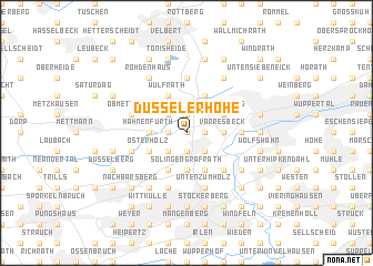
Düsselerhöhe (Nordrhein-Westfalen, Germany)Düsselerhöhe is a town in the Nordrhein-Westfalen region of Germany. An overview map of the region around Düsselerhöhe is displayed below.
regional and 3d topo map of Düsselerhöhe, Germany ::
Düsselerhöhe airports ::
The nearest airport is ESS - Essen Mulheim, located 19.2 km north west of Düsselerhöhe.
Other airports nearby include DUS - Duesseldorf Dusseldorf (21.4 km west), MGL - Moenchengladbach Monchengladbach (39.3 km west), CGN - Cologne Koln Bonn (43.1 km south), DTM - Dortmund (48.3 km north east), Nearby towns ::
Buntenbeck (0.0km north) //
Dornap (0.0km north) //
Wieden (1.2km east) //
Schickenberg (1.2km east) //
Lüntenbeck (1.2km east) //
Saurenhaus (1.2km east) //
Unterdüssel (1.2km west) //
Rottscheidt (1.9km south) //
Grotenbeck (1.9km south) //
Tesche (1.9km south) //
Aprath (1.9km north) //
Sonnborn (2.2km south east) //
Hammerstein (2.2km south east) //
Düssel (2.2km north west) //
Holthausen (2.2km south west) //
Varresbeck (2.3km east) //
Scheidt (2.3km east) //
Gräfrath (3.7km south) //
Solingen-Gräfrath (3.7km south) //
Kluse (3.7km south) //
Hahnenfurth (2.3km west) //
Roßkampe (3.9km south) //
Oberdüssel (3.9km north) //
Katernberg (3.0km north east) //
Wülfrath (3.9km north) //
Simonshaus (3.9km south) //
Osterholz (3.0km south west) //
Evertsaue (4.4km south east) //
Großehöhe (5.6km north) //
[all distances 'as the bird flies' and approximate]  Places with similar names to Düsselerhöhe, Germany :: Disclaimer :: Information on this page comes without warranty of any kind |
||
|
Where is Düsselerhöhe? Elevation and coordinates ::
Latitude (lat): 51°15'0"N Longitude (lon): 7°4'0"E
Elevation (approx.): 191m (map arrows pan, magnifying glasses zoom) |
||
|
Visiting Düsselerhöhe? Hotel/Accommodation ::
Book a hotel in Düsselerhöhe Travel Guide ::
Buy a travel guide for Germany rental cars ::
car rental offers GPS waypoint ::
download a GPX waypoint (PoI) of Düsselerhöhe for your GPS receiver
|
||