|
search place name
|
||
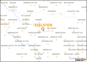
Egelstein (Baden-Württemberg, Germany)Egelstein is a town in the Baden-Württemberg region of Germany. An overview map of the region around Egelstein is displayed below.
regional and 3d topo map of Egelstein, Germany ::
Egelstein airports ::
The nearest airport is STR - Stuttgart, located 37.4 km north west of Egelstein.
Other airports nearby include FDH - Friedrichshafen (82.9 km south), ZQL - Donaueschingen Villingen (88.9 km south west), ACH - St Gallen Altenrhein (103.6 km south), AGB - Augsburg (104.7 km east), Nearby towns ::
Auingen (0.0km north) //
Langenwag (1.2km east) //
Münsingen (1.2km west) //
Trailfingen (2.2km north west) //
Altes Lager (2.5km east) //
Böttingen (2.5km east) //
Oberheutal (3.7km south) //
Gruorn (3.9km north) //
Ziegelhäuser (3.1km south west) //
Unterheutal (5.7km south) //
Fauserhöhe (4.1km south west) //
Apfelstetten (6.1km south west) //
Buttenhausen (6.1km south west) //
Mehrstetten (5.2km south east) //
Magolsheim (5.3km east) //
Rietheim (5.3km west) //
Zainingen (7.8km north) //
Seeburg (6.2km north west) //
Hundersingen (7.8km south) //
Hengen (8.3km north west) //
Wittlingen (7.4km north west) //
Heuberg (8.9km north east) //
[all distances 'as the bird flies' and approximate] 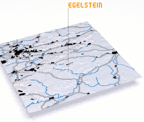 Places with similar names to Egelstein, Germany :: Disclaimer :: Information on this page comes without warranty of any kind |
||
|
Where is Egelstein? Elevation and coordinates ::
Latitude (lat): 48°25'0"N Longitude (lon): 9°31'0"E
Elevation (approx.): 724m (map arrows pan, magnifying glasses zoom) |
||
|
Visiting Egelstein? Hotel/Accommodation ::
Book a hotel in Egelstein Travel Guide ::
Buy a travel guide for Germany rental cars ::
car rental offers GPS waypoint ::
download a GPX waypoint (PoI) of Egelstein for your GPS receiver
|
||