|
search place name
|
||
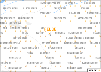
Felde (Niedersachsen, Germany)Felde is a town in the Niedersachsen region of Germany. An overview map of the region around Felde is displayed below.
regional and 3d topo map of Felde, Germany ::
Felde airports ::
The nearest airport is EME - Emden, located 25.2 km west of Felde.
Other airports nearby include WVN - Wilhelmshaven Mariensiel (31.1 km east), NRD - Norderney (39.1 km north west), BMK - Borkum (61.8 km west), BRV - Bremerhaven (65.1 km east), Nearby towns ::
Aurich-Oldendorf (1.9km south) //
Wrisse (1.1km west) //
Wiesens (2.2km north west) //
Akelsbarg (2.2km north west) //
Holtrop (2.2km west) //
Moorlage (2.2km east) //
Ostgroßefehn (3.7km south) //
Zwischenmooren (2.9km south east) //
Holtroperfeld (2.9km north west) //
Neue Wieke (3.9km south) //
Bülte (3.8km south east) //
Spetzerfehn (5.7km south) //
Heidhörnerweg (5.7km south) //
Brockzetel (6.0km north) //
Mittegroßefehn (5.0km south west) //
Ulbargen (7.5km south) //
Bietzefeld (4.8km south west) //
Pfalzdorf (7.5km north) //
Strackholt (7.7km south) //
Auricher Wiesmoor Eins (7.1km north east) //
Westgroßefehn (7.1km south west) //
Timmel (8.6km south west) //
[all distances 'as the bird flies' and approximate]  Places with similar names to Felde, Germany ::
Disclaimer :: Information on this page comes without warranty of any kind |
||
|
Where is Felde? Elevation and coordinates ::
Latitude (lat): 53°26'0"N Longitude (lon): 7°36'0"E
Elevation (approx.): 4m (map arrows pan, magnifying glasses zoom) |
||
|
Visiting Felde? Hotel/Accommodation ::
Book a hotel in Felde Travel Guide ::
Buy a travel guide for Germany rental cars ::
car rental offers GPS waypoint ::
download a GPX waypoint (PoI) of Felde for your GPS receiver
|
||