|
search place name
|
||
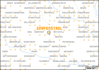
Grafenstadl (Bayern, Germany)Grafenstadl is a town in the Bayern region of Germany. An overview map of the region around Grafenstadl is displayed below.
regional and 3d topo map of Grafenstadl, Germany ::
Grafenstadl airports ::
The nearest airport is MUC - Munich Munchen, located 73.7 km south of Grafenstadl.
Other airports nearby include NUE - Nuernberg Nurnberg (74.8 km north west), AGB - Augsburg (90.8 km south west), FEL - Fuerstenfeldbruck Furstenfeldbruck (97.9 km south west), BYU - Bayreuth (108.1 km north), Nearby towns ::
Arnest (1.9km north) //
Höfen (1.9km north) //
Bügerleithen (1.2km west) //
Winkl (1.9km north) //
Aichkirchen (1.2km west) //
Hamberg (1.2km east) //
Hennhüll (1.2km east) //
Lautersee (1.9km south) //
Oberhöfen (1.9km south) //
Stadla (2.2km north west) //
Klingen (2.2km north east) //
Kumpfhof (2.4km west) //
Bügerl (2.4km west) //
Aicha (2.4km west) //
Mantlach (2.4km east) //
Netzstall (2.4km east) //
Maierhofen (3.7km south) //
Hemau (4.1km north) //
Painten (3.1km south east) //
Langenkreith (4.4km north west) //
Neulohe (4.4km south east) //
Flinksberg (5.6km north) //
Schacha (4.1km north east) //
Altenlohe (4.1km north west) //
Keilsdorf (5.7km south) //
Kollersried (5.7km north) //
Thonhausen (5.2km north east) //
Eiersdorf (5.2km north east) //
Eibrunn (5.2km north east) //
[all distances 'as the bird flies' and approximate]  Places with similar names to Grafenstadl, Germany :: Disclaimer :: Information on this page comes without warranty of any kind |
||
|
Where is Grafenstadl? Elevation and coordinates ::
Latitude (lat): 49°1'0"N Longitude (lon): 11°47'0"E
Elevation (approx.): 572m (map arrows pan, magnifying glasses zoom) |
||
|
Visiting Grafenstadl? Hotel/Accommodation ::
Book a hotel in Grafenstadl Travel Guide ::
Buy a travel guide for Germany rental cars ::
car rental offers GPS waypoint ::
download a GPX waypoint (PoI) of Grafenstadl for your GPS receiver
|
||