|
search place name
|
||
Greimerath (Rheinland-Pfalz, Germany)Greimerath is a town in the Rheinland-Pfalz region of Germany. An overview map of the region around Greimerath is displayed below.
regional and 3d topo map of Greimerath, Germany ::

Greimerath airports ::
The nearest airport is ZQF - Trier Fohren, located 33.9 km north of Greimerath.
Other airports nearby include LUX - Luxemburg Luxembourg (34.8 km west), SPM - Spangdahlem Ab (45.2 km north), SCN - Saarbruecken Saarbrucken (49.9 km south east), HHN - Frankfurt Hahn (59.6 km north east), Nearby towns ::
Oberzerf (1.9km north) //
Kalfertshaus (2.2km north west) //
Zerf (3.7km north) //
Niederzerf (3.7km north) //
Frommersbach (3.9km north) //
Bergen (3.9km south) //
Britten (5.6km south) //
Baldringen (5.6km north) //
Scheiden (4.1km south east) //
Hentern (5.7km north) //
Paschel (7.4km north) //
Hausbach (7.4km south) //
Steinbachweier (7.5km north) //
Schömerich (7.5km north) //
Saarhölzbach (7.4km south west) //
Losheim (7.4km south east) //
[all distances 'as the bird flies' and approximate] 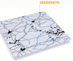 Places with similar names to Greimerath, Germany ::
// Kürmreuth (DE)
// Greimerath (DE)
Disclaimer :: Information on this page comes without warranty of any kind |
||
|
Where is Greimerath? Elevation and coordinates ::
Latitude (lat): 49°34'0"N Longitude (lon): 6°41'0"E
Elevation (approx.): 471m (map arrows pan, magnifying glasses zoom) |
||
|
Visiting Greimerath? Hotel/Accommodation ::
Book a hotel in Greimerath Travel Guide ::
Buy a travel guide for Germany rental cars ::
car rental offers GPS waypoint ::
download a GPX waypoint (PoI) of Greimerath for your GPS receiver
|
||