|
search place name
|
||
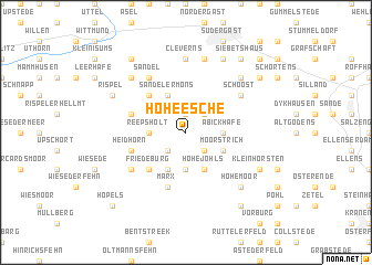
Hoheesche (Niedersachsen, Germany)Hoheesche is a town in the Niedersachsen region of Germany. An overview map of the region around Hoheesche is displayed below.
regional and 3d topo map of Hoheesche, Germany ::
Hoheesche airports ::
The nearest airport is WVN - Wilhelmshaven Mariensiel, located 12.6 km east of Hoheesche.
Other airports nearby include EME - Emden (43.7 km west), BRV - Bremerhaven (46.9 km east), NRD - Norderney (48.9 km north west), BMK - Borkum (77.7 km west), Nearby towns ::
Langstraße (1.9km north) //
Riepen (2.2km south east) //
Hesel (2.2km south west) //
Lopsum (2.2km north east) //
Dose (2.2km north east) //
Stapelstein (3.7km south) //
Abickhafe (2.2km east) //
Reepsholt (2.2km west) //
Hohejohls (3.9km south) //
Moorstrich (2.9km south east) //
Etzel (2.9km south east) //
Strudden (3.9km south) //
Sandeler Möns (3.9km north) //
Friedeburg (4.3km south west) //
Grappermöns (4.3km north west) //
Heidhörn (3.8km south west) //
Bunkenburg (5.7km south) //
Marx (5.7km south) //
Bohmfield (3.8km north west) //
Rußland (5.0km south west) //
Schoost (5.0km north east) //
Sandel (6.0km north) //
Cleverns (7.4km north) //
Barderstede (7.4km north) //
Rahrdum (7.5km north) //
Hohemoor (6.5km south east) //
Möns (6.5km north west) //
Oestringfelde (6.5km north east) //
Bült (5.8km south east) //
[all distances 'as the bird flies' and approximate]  Places with similar names to Hoheesche, Germany ::
// Huahuasco (MX)
Disclaimer :: Information on this page comes without warranty of any kind |
||
|
Where is Hoheesche? Elevation and coordinates ::
Latitude (lat): 53°29'0"N Longitude (lon): 7°52'0"E
(map arrows pan, magnifying glasses zoom) |
||
|
Visiting Hoheesche? Hotel/Accommodation ::
Book a hotel in Hoheesche Travel Guide ::
Buy a travel guide for Germany rental cars ::
car rental offers GPS waypoint ::
download a GPX waypoint (PoI) of Hoheesche for your GPS receiver
|
||