|
search place name
|
||
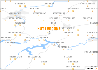
Hüttenrode (Sachsen-Anhalt, Germany)Hüttenrode is a town in the Sachsen-Anhalt region of Germany. An overview map of the region around Hüttenrode is displayed below.
regional and 3d topo map of Hüttenrode, Germany ::
Hüttenrode airports ::
The nearest airport is BWE - Braunschweig Wolfsburg, located 65.8 km north of Hüttenrode.
Other airports nearby include ERF - Erfurt (87.6 km south), LEJ - Leipzig Halle (100.1 km east), ZCN - Celle (109.6 km north west), KSF - Kassel Calden (112.8 km west), Nearby towns ::
Neuwerk (2.2km south west) //
Oesig (3.9km north) //
Michaelstein (3.9km north) //
Kreuztal (2.9km south west) //
Wendefurth (3.9km south) //
Altenbrak (4.4km south east) //
Blankenburg (3.9km north east) //
Heiligenkopf (5.7km north) //
Heimburg (5.7km north) //
Wienrode (4.6km east) //
Cattenstedt (4.9km east) //
Rübeland (4.9km west) //
Treseburg (6.5km south east) //
Pfeifenkrug (7.8km north) //
Benzingerode (7.8km north) //
Lessingplatz (7.2km north east) //
[all distances 'as the bird flies' and approximate] 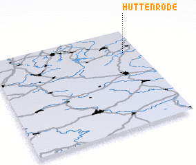 Places with similar names to Hüttenrode, Germany ::
// Heitenried (CH)
// Hattenrod (DE)
// Hüttenreute (DE)
// Huttenried (DE)
// Hüttenroda (DE)
// Hüttenrode (DE)
// Hednoret (SE)
Disclaimer :: Information on this page comes without warranty of any kind |
||
|
Where is Hüttenrode? Elevation and coordinates ::
Latitude (lat): 51°46'0"N Longitude (lon): 10°54'0"E
Elevation (approx.): 485m (map arrows pan, magnifying glasses zoom) |
||
|
Visiting Hüttenrode? Hotel/Accommodation ::
Book a hotel in Hüttenrode Travel Guide ::
Buy a travel guide for Germany rental cars ::
car rental offers GPS waypoint ::
download a GPX waypoint (PoI) of Hüttenrode for your GPS receiver
|
||