|
search place name
|
||
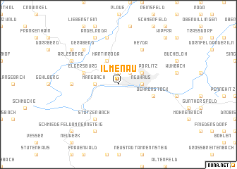
Ilmenau (Thüringen, Germany)Ilmenau is a town in the Thüringen region of Germany. An overview map of the region around Ilmenau is displayed below.
regional and 3d topo map of Ilmenau, Germany ::
Ilmenau airports ::
The nearest airport is ERF - Erfurt, located 33.2 km north of Ilmenau.
Other airports nearby include HOQ - Hof Plauen (80.7 km south east), BYU - Bayreuth (93.9 km south east), AOC - Altenburg Nobitz (117.9 km east), LEJ - Leipzig Halle (125.7 km north east), Nearby towns ::
Roda (1.9km north) //
Oberpörlitz (2.2km north east) //
Neuhaus (2.3km east) //
Manebach (2.3km west) //
Unterpörlitz (3.0km north east) //
Martinroda (3.9km north) //
Oehrenstock (4.0km south east) //
Elgersburg (4.0km north west) //
Heyda (6.0km north east) //
Stützerbach (6.0km south west) //
Mönchshof (4.7km west) //
Neusiß (7.5km north) //
Geraberg (6.6km north west) //
Allzunah (7.8km south) //
Angelroda (7.8km north) //
Arlesberg (6.0km north west) //
Geschwenda (7.3km north west) //
Schmiedefeld am Rennsteig (8.8km south west) //
Wipfra (8.8km north east) //
[all distances 'as the bird flies' and approximate] 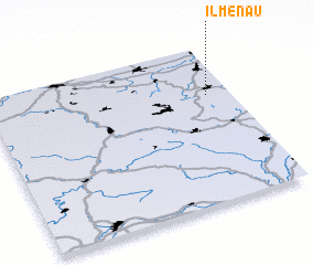 Places with similar names to Ilmenau, Germany ::
Disclaimer :: Information on this page comes without warranty of any kind |
||
|
Where is Ilmenau? Elevation and coordinates ::
Latitude (lat): 50°41'0"N Longitude (lon): 10°54'0"E
Elevation (approx.): 539m (map arrows pan, magnifying glasses zoom) |
||
|
Visiting Ilmenau? Hotel/Accommodation ::
Book a hotel in Ilmenau Travel Guide ::
Buy a travel guide for Germany rental cars ::
car rental offers GPS waypoint ::
download a GPX waypoint (PoI) of Ilmenau for your GPS receiver
|
||