|
search place name
|
||
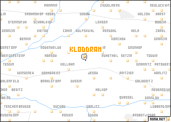
Kloddram (Mecklenburg-Vorpommern, Germany)Kloddram is a town in the Mecklenburg-Vorpommern region of Germany. An overview map of the region around Kloddram is displayed below.
regional and 3d topo map of Kloddram, Germany ::
Kloddram airports ::
The nearest airport is LBC - Luebeck Lubeck Blankensee, located 47.1 km north west of Kloddram.
Other airports nearby include SZW - Schwerin Parchim (52.1 km east), HAM - Hamburg (71.2 km west), XFW - Hamburg Finkenwerder (78.3 km west), RLG - Laage (101.3 km north east), Nearby towns ::
Albertinenhof (1.9km north) //
Zühr (2.9km north east) //
Goldenbow (2.9km north west) //
Vellahn (2.9km south west) //
Jesow (3.9km south) //
Wulfskuhl (5.6km north) //
Ruhethal (3.3km east) //
Düssin (5.7km south) //
Camin (6.0km north) //
Schwechow (5.0km south east) //
Marsow (4.4km west) //
Rodenwalde (4.8km north west) //
Langenheide (7.5km south) //
Perdöhl (6.5km north east) //
Lehsen (7.7km north) //
Melkof (7.7km south) //
Körchow (5.8km north east) //
Dammereez (5.8km south west) //
Brahlstorf (7.1km south west) //
[all distances 'as the bird flies' and approximate] 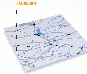 Places with similar names to Kloddram, Germany ::
Disclaimer :: Information on this page comes without warranty of any kind |
||
|
Where is Kloddram? Elevation and coordinates ::
Latitude (lat): 53°25'0"N Longitude (lon): 11°0'0"E
Elevation (approx.): 51m (map arrows pan, magnifying glasses zoom) |
||
|
Visiting Kloddram? Hotel/Accommodation ::
Book a hotel in Kloddram Travel Guide ::
Buy a travel guide for Germany rental cars ::
car rental offers GPS waypoint ::
download a GPX waypoint (PoI) of Kloddram for your GPS receiver
|
||