|
search place name
|
||
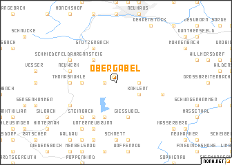
Obergabel (Thüringen, Germany)Obergabel is a town in the Thüringen region of Germany. An overview map of the region around Obergabel is displayed below.
regional and 3d topo map of Obergabel, Germany ::
Obergabel airports ::
The nearest airport is ERF - Erfurt, located 44.3 km north of Obergabel.
Other airports nearby include HOQ - Hof Plauen (75.3 km south east), BYU - Bayreuth (84.9 km south east), NUE - Nuernberg Nurnberg (121.2 km south), AOC - Altenburg Nobitz (121.6 km east), Nearby towns ::
Untergabel (1.2km west) //
Neustadt am Rennsteig (2.4km east) //
Kahlert (3.0km south east) //
Allzunah (4.4km north west) //
Frauenwald (3.5km west) //
Schönbrunn (5.7km south) //
Gießübel (5.7km south) //
Oberneubrunn (5.7km south) //
Schönau (6.0km south west) //
Stützerbach (6.0km north west) //
Thomasmühle (4.7km west) //
Altenfeld (5.1km east) //
Neuwerk (5.1km west) //
Steinbach (6.6km south west) //
Unterneubrunn (7.8km south) //
Schönau (7.8km south) //
Schleusingerneuendorf (6.0km south west) //
Schmiedefeld am Rennsteig (6.0km north west) //
Langenbach (8.2km south west) //
[all distances 'as the bird flies' and approximate]  Places with similar names to Obergabel, Germany :: Disclaimer :: Information on this page comes without warranty of any kind |
||
|
Where is Obergabel? Elevation and coordinates ::
Latitude (lat): 50°35'0"N Longitude (lon): 10°54'0"E
Elevation (approx.): 761m (map arrows pan, magnifying glasses zoom) |
||
|
Visiting Obergabel? Hotel/Accommodation ::
Book a hotel in Obergabel Travel Guide ::
Buy a travel guide for Germany rental cars ::
car rental offers GPS waypoint ::
download a GPX waypoint (PoI) of Obergabel for your GPS receiver
|
||