|
search place name
|
||
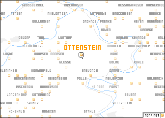
Ottenstein (Niedersachsen, Germany)Ottenstein is a town in the Niedersachsen region of Germany. An overview map of the region around Ottenstein is displayed below.
regional and 3d topo map of Ottenstein, Germany ::
Ottenstein airports ::
The nearest airport is HAJ - Hannover, located 60.1 km north of Ottenstein.
Other airports nearby include KSF - Kassel Calden (60.3 km south), PAD - Paderborn Lippstadt (65.7 km south west), GUT - Guetersloh Gutersloh (75.3 km west), ZCN - Celle (83.0 km north east), Nearby towns ::
Glesse (2.9km south west) //
Brevörde (3.9km south) //
Lüntorf (4.4km north west) //
Neersen (3.4km west) //
Polle (5.6km south) //
Lichtenhagen (3.9km north west) //
Deitlevsen (5.0km north west) //
Vahlbruch (5.0km south west) //
Hohe (4.6km east) //
Brökeln (4.9km east) //
Grohnde (7.5km north) //
Dölme (4.9km east) //
Eichenborn (4.9km west) //
Hajen (6.5km north east) //
Meiborssen (6.5km south west) //
Daspe (5.9km north east) //
Grave (5.9km south east) //
Heinsen (7.8km south) //
Frenke (8.2km north east) //
Welsede (8.2km north west) //
Reileifzen (7.2km south east) //
Hünkergrund (7.2km south west) //
Forst (8.7km south east) //
Hummersen (8.7km south west) //
[all distances 'as the bird flies' and approximate]  Places with similar names to Ottenstein, Germany ::
// Ottenstein (AT)
// Ottenstein (DE)
Disclaimer :: Information on this page comes without warranty of any kind |
||
|
Where is Ottenstein? Elevation and coordinates ::
Latitude (lat): 51°57'0"N Longitude (lon): 9°24'0"E
Elevation (approx.): 301m (map arrows pan, magnifying glasses zoom) |
||
|
Visiting Ottenstein? Hotel/Accommodation ::
Book a hotel in Ottenstein Travel Guide ::
Buy a travel guide for Germany rental cars ::
car rental offers GPS waypoint ::
download a GPX waypoint (PoI) of Ottenstein for your GPS receiver
|
||