|
search place name
|
||
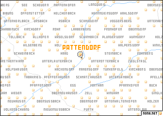
Pattendorf (Bayern, Germany)Pattendorf is a town in the Bayern region of Germany. An overview map of the region around Pattendorf is displayed below.
regional and 3d topo map of Pattendorf, Germany ::
Pattendorf airports ::
The nearest airport is MUC - Munich Munchen, located 43.8 km south west of Pattendorf.
Other airports nearby include FEL - Fuerstenfeldbruck Furstenfeldbruck (79.4 km south west), AGB - Augsburg (86.4 km west), OBF - Oberpfaffenhofen (89.1 km south west), NUE - Nuernberg Nurnberg (111.2 km north west), Nearby towns ::
Gisseltshausen (0.0km north) //
Schaltdorf (1.9km north) //
Kreuzthann (1.2km east) //
Rottenburg an der Laaber (2.2km south east) //
Krumbach (2.2km south east) //
Bogenhausen (2.2km south west) //
Niederhatzkofen (2.2km south west) //
Oberhatzkofen (2.2km south west) //
Högldorf (3.7km north) //
Au (3.7km north) //
Haag (2.4km west) //
Münster (3.1km north east) //
Schirmbach (3.9km north) //
Oberotterbach (3.1km south east) //
Niedereulenbach (3.9km north) //
Ramersdorf (3.9km south) //
Eschenloh (3.9km south) //
Wolferthau (3.1km north west) //
Hochreuth (4.4km south east) //
Waselsdorf (4.4km north west) //
Obereulenbach (4.4km north west) //
Hackendorf (4.4km south west) //
Kalteneck (5.6km north) //
Laaberberg (5.6km north) //
Schmatzhausen (5.7km south) //
Oberbuch (4.1km north west) //
Unterlauterbach (4.1km south west) //
Schlamberg (4.1km south east) //
Unterotterbach (4.1km south east) //
[all distances 'as the bird flies' and approximate]  Places with similar names to Pattendorf, Germany ::
// Pattendorf (AT)
// Pattendorf (AT)
// Pettendorf (AT)
// Pettendorf (AT)
// Pöttendorf (AT)
// Pottendorf (AT)
// Pattendorf (DE)
// Pettendorf (DE)
// Pettendorf (DE)
// Pettendorf (DE)
Disclaimer :: Information on this page comes without warranty of any kind |
||
|
Where is Pattendorf? Elevation and coordinates ::
Latitude (lat): 48°43'0"N Longitude (lon): 12°1'0"E
Elevation (approx.): 414m (map arrows pan, magnifying glasses zoom) |
||
|
Visiting Pattendorf? Hotel/Accommodation ::
Book a hotel in Pattendorf Travel Guide ::
Buy a travel guide for Germany rental cars ::
car rental offers GPS waypoint ::
download a GPX waypoint (PoI) of Pattendorf for your GPS receiver
|
||