|
search place name
|
||
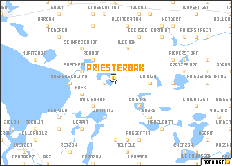
Priesterbak (Mecklenburg-Vorpommern, Germany)Priesterbak is a town in the Mecklenburg-Vorpommern region of Germany. An overview map of the region around Priesterbak is displayed below.
regional and 3d topo map of Priesterbak, Germany ::
Priesterbak airports ::
The nearest airport is RLG - Laage, located 67.4 km north west of Priesterbak.
Other airports nearby include SZW - Schwerin Parchim (70.9 km west), TXL - Berlin Tegel (99.8 km south), THF - Berlin Tempelhof (111.4 km south), SXF - Berlin Schonefeld (123.9 km south), Nearby towns ::
Speck (1.9km north) //
Faule Ort (1.1km west) //
Rehhof (4.3km north west) //
Amalienhof (4.3km south west) //
Krienke (4.3km south east) //
Granzin (3.3km east) //
Specker Horst (3.8km north west) //
Zartwitz (5.7km south) //
Klockow (5.7km north) //
Boek (3.8km south west) //
Boeker Schlamm (4.4km west) //
Schwarzenhof (6.5km north west) //
Babke (6.5km south east) //
Bocksee (7.7km north) //
Leppin (8.1km south west) //
Bornhof (8.6km north east) //
Blankenförde (8.6km south east) //
Kakeldütt (8.6km south east) //
[all distances 'as the bird flies' and approximate]  Places with similar names to Priesterbak, Germany :: Disclaimer :: Information on this page comes without warranty of any kind |
||
|
Where is Priesterbak? Elevation and coordinates ::
Latitude (lat): 53°25'0"N Longitude (lon): 12°51'0"E
Elevation (approx.): 70m (map arrows pan, magnifying glasses zoom) |
||
|
Visiting Priesterbak? Hotel/Accommodation ::
Book a hotel in Priesterbak Travel Guide ::
Buy a travel guide for Germany rental cars ::
car rental offers GPS waypoint ::
download a GPX waypoint (PoI) of Priesterbak for your GPS receiver
|
||