|
search place name
|
||
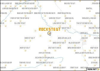
Rockstedt (Niedersachsen, Germany)Rockstedt is a town in the Niedersachsen region of Germany. An overview map of the region around Rockstedt is displayed below.
regional and 3d topo map of Rockstedt, Germany ::
Rockstedt airports ::
The nearest airport is BRE - Bremen, located 39.3 km south west of Rockstedt.
Other airports nearby include BRV - Bremerhaven (44.8 km north west), XFW - Hamburg Finkenwerder (50.8 km north east), HAM - Hamburg (64.8 km north east), WVN - Wilhelmshaven Mariensiel (76.9 km west), Nearby towns ::
Ostereistedt (1.9km south) //
Rhadereistedt (2.2km west) //
Lavenstedt (4.3km north east) //
Badenstedt (4.3km south east) //
Ostertimke (5.7km south) //
Godenstedt (3.8km north east) //
Rhade (3.8km north west) //
Granstedt (5.7km north) //
Wentel (5.7km south) //
Bademühlen (3.8km south east) //
Ober Ochtenhausen (7.5km north) //
Kirchtimke (7.5km south) //
Hanstedt (4.8km south west) //
Selsingen (6.5km north east) //
Seedorf (5.8km north east) //
Parnewinkel (8.1km north east) //
Haaßel (7.1km north east) //
[all distances 'as the bird flies' and approximate] 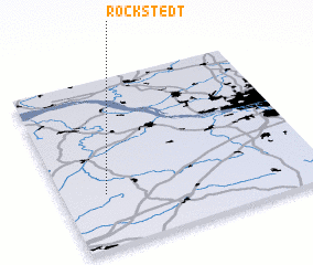 Places with similar names to Rockstedt, Germany ::
// Rockstedt (DE)
Disclaimer :: Information on this page comes without warranty of any kind |
||
|
Where is Rockstedt? Elevation and coordinates ::
Latitude (lat): 53°19'0"N Longitude (lon): 9°10'0"E
Elevation (approx.): 24m (map arrows pan, magnifying glasses zoom) |
||
|
Visiting Rockstedt? Hotel/Accommodation ::
Book a hotel in Rockstedt Travel Guide ::
Buy a travel guide for Germany rental cars ::
car rental offers GPS waypoint ::
download a GPX waypoint (PoI) of Rockstedt for your GPS receiver
|
||