|
search place name
|
||
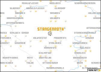
Stangenroth (Bayern, Germany)Stangenroth is a town in the Bayern region of Germany. An overview map of the region around Stangenroth is displayed below.
regional and 3d topo map of Stangenroth, Germany ::
Stangenroth airports ::
The nearest airport is GHF - Giebelstadt Aaf, located 70.7 km south of Stangenroth.
Other airports nearby include ZNF - Hanau Aaf (74.0 km west), ERF - Erfurt (103.7 km north east), FRA - Frankfurt Main (106.8 km west), NUE - Nuernberg Nurnberg (117.0 km south east), Nearby towns ::
Gefäll (1.9km north) //
Wollbach bei Bad Kissingen (2.2km south east) //
Burkardroth (2.2km south east) //
Zahlbach (2.2km south east) //
Waldfenster (3.0km south west) //
Lauter bei Bad Kissingen (3.9km south) //
Katzenbach (3.9km south) //
Stralsbach (3.9km south) //
Frauenroth (3.0km south east) //
Premich (3.0km north east) //
Steinberg (3.0km north east) //
Langenleiten (5.6km north) //
Poppenroth (5.6km south) //
Waldberg (5.7km north) //
Platz (5.1km west) //
Schlimpfhof (7.5km south) //
Sandberg (7.5km north) //
Schmalwasser (6.6km north east) //
Oehrberg (6.0km south west) //
Hassenbach (7.8km south) //
Aschach bei Bad Kissingen (6.0km south east) //
[all distances 'as the bird flies' and approximate]  Places with similar names to Stangenroth, Germany :: Disclaimer :: Information on this page comes without warranty of any kind |
||
|
Where is Stangenroth? Elevation and coordinates ::
Latitude (lat): 50°17'0"N Longitude (lon): 9°59'0"E
Elevation (approx.): 379m (map arrows pan, magnifying glasses zoom) |
||
|
Visiting Stangenroth? Hotel/Accommodation ::
Book a hotel in Stangenroth Travel Guide ::
Buy a travel guide for Germany rental cars ::
car rental offers GPS waypoint ::
download a GPX waypoint (PoI) of Stangenroth for your GPS receiver
|
||