|
search place name
|
||
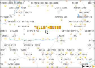
Tellerhäuser (Sachsen, Germany)Tellerhäuser is a town in the Sachsen region of Germany. An overview map of the region around Tellerhäuser is displayed below.
regional and 3d topo map of Tellerhäuser, Germany ::
Tellerhäuser airports ::
The nearest airport is KLV - Karlovy Vary, located 25.6 km south of Tellerhäuser.
Other airports nearby include AOC - Altenburg Nobitz (67.1 km north west), HOQ - Hof Plauen (76.1 km west), DRS - Dresden (99.0 km north east), BYU - Bayreuth (103.0 km south west), Nearby towns ::
Boží Dar (1.9km south) //
Myslivny (2.2km south west) //
Neues Haus (3.0km south east) //
Zweibach (3.0km north west) //
Zlatý Kopec (3.5km west) //
Loučná (4.0km south east) //
Klínovec (5.1km south east) //
Vršek (6.0km south west) //
Nové Město (7.4km south) //
Zálesí (7.5km south) //
Jáchymov (7.5km south) //
Siebensäure (6.6km north east) //
Ryžovna (6.0km south west) //
Ehrenzipfel (6.0km north west) //
Suchá (8.2km south east) //
Hřebečná (7.3km south west) //
Léno (8.8km south east) //
[all distances 'as the bird flies' and approximate] 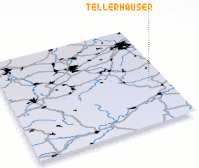 Places with similar names to Tellerhäuser, Germany :: Disclaimer :: Information on this page comes without warranty of any kind |
||
|
Where is Tellerhäuser? Elevation and coordinates ::
Latitude (lat): 50°26'0"N Longitude (lon): 12°54'0"E
Elevation (approx.): 957m (map arrows pan, magnifying glasses zoom) |
||
|
Visiting Tellerhäuser? Hotel/Accommodation ::
Book a hotel in Tellerhäuser Travel Guide ::
Buy a travel guide for Germany rental cars ::
car rental offers GPS waypoint ::
download a GPX waypoint (PoI) of Tellerhäuser for your GPS receiver
|
||