|
search place name
|
||
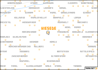
Wiesede (Niedersachsen, Germany)Wiesede is a town in the Niedersachsen region of Germany. An overview map of the region around Wiesede is displayed below.
regional and 3d topo map of Wiesede, Germany ::
Wiesede airports ::
The nearest airport is WVN - Wilhelmshaven Mariensiel, located 18.9 km east of Wiesede.
Other airports nearby include EME - Emden (37.5 km west), NRD - Norderney (46.5 km north west), BRV - Bremerhaven (52.8 km east), BMK - Borkum (73.1 km west), Nearby towns ::
Wiesederfehn (2.2km south west) //
Brinkenshöhe (2.2km west) //
Rußland (2.2km east) //
Upschört (2.9km north west) //
Hopels (3.9km south) //
Heidhörn (2.9km north east) //
Friedeburg (3.3km east) //
Reepsholt (5.0km north east) //
Neuenweg (5.0km north west) //
Rispelerhellmt (6.0km north) //
Wiesmoor (5.0km south west) //
Mullberg (6.0km south) //
Bohmfield (6.0km north) //
Marcardsmoor (4.4km west) //
Strudden (4.4km east) //
Hesel (4.8km north east) //
Rispel (7.5km north) //
Bunkenburg (4.8km south east) //
Marx (4.8km south east) //
Wiesedermeer (5.8km north west) //
Müggenkrug (8.1km north west) //
Grappermöns (8.1km north east) //
Bentstreek (8.1km south east) //
Schnapp (8.6km north west) //
Sandeler Möns (8.6km north east) //
[all distances 'as the bird flies' and approximate]  Places with similar names to Wiesede, Germany ::
Disclaimer :: Information on this page comes without warranty of any kind |
||
|
Where is Wiesede? Elevation and coordinates ::
Latitude (lat): 53°27'0"N Longitude (lon): 7°47'0"E
Elevation (approx.): 8m (map arrows pan, magnifying glasses zoom) |
||
|
Visiting Wiesede? Hotel/Accommodation ::
Book a hotel in Wiesede Travel Guide ::
Buy a travel guide for Germany rental cars ::
car rental offers GPS waypoint ::
download a GPX waypoint (PoI) of Wiesede for your GPS receiver
|
||