|
search place name
|
||
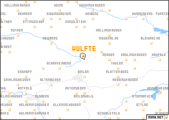
Wülfte (Nordrhein-Westfalen, Germany)Wülfte is a town in the Nordrhein-Westfalen region of Germany. An overview map of the region around Wülfte is displayed below.
regional and 3d topo map of Wülfte, Germany ::
Wülfte airports ::
The nearest airport is PAD - Paderborn Lippstadt, located 20.2 km north of Wülfte.
Other airports nearby include ZCA - Arnsberg Menden (47.9 km west), KSF - Kassel Calden (55.3 km east), GUT - Guetersloh Gutersloh (57.7 km north), DTM - Dortmund (68.1 km west), Nearby towns ::
Brilon (3.7km south) //
Alme (3.0km north east) //
Haus Tinne (3.0km north east) //
Oberalme (3.0km north east) //
Nehden (3.5km east) //
Scharfenberg (3.9km south west) //
Berenscheid (5.1km north east) //
Niederalme (5.1km north east) //
Gudenhagen (7.4km south) //
Harth (7.4km north) //
Petersborn (7.5km south) //
Ringelstein (7.5km north) //
Thülen (5.0km east) //
Hallinghausen (6.6km north east) //
Heidberg (5.9km north west) //
Plattenberg (5.9km south east) //
Altenbüren (7.2km south west) //
Hoppecke (7.2km south east) //
Kneblinghausen (8.7km north west) //
[all distances 'as the bird flies' and approximate] 
Disclaimer :: Information on this page comes without warranty of any kind |
||
|
Where is Wülfte? Elevation and coordinates ::
Latitude (lat): 51°26'0"N Longitude (lon): 8°35'0"E
Elevation (approx.): 447m (map arrows pan, magnifying glasses zoom) |
||
|
Visiting Wülfte? Hotel/Accommodation ::
Book a hotel in Wülfte Travel Guide ::
Buy a travel guide for Germany rental cars ::
car rental offers GPS waypoint ::
download a GPX waypoint (PoI) of Wülfte for your GPS receiver
|
||