|
search place name
|
||
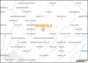
Armarolo (Italy)Armarolo is a town in Italy. An overview map of the region around Armarolo is displayed below.
regional and 3d topo map of Armarolo, Italy ::
Armarolo airports ::
The nearest airport is BLQ - Bologna, located 15.9 km south west of Armarolo.
Other airports nearby include FRL - Forli (65.9 km south east), FLR - Firenze (90.2 km south), QPA - Padova (93.4 km north), PMF - Parma (96.0 km west), Nearby towns ::
Minerbio (2.3km north east) //
Possessione Colombara (3.7km south) //
Cazzano (3.2km south east) //
San Marco (4.0km west) //
Saletto (5.7km north) //
San Marino (4.4km north west) //
Osteriola (4.4km south west) //
San Martino in Soverzano (4.4km north east) //
Granarolo del lʼEmilia (5.7km south) //
Bentivoglio (5.4km north west) //
Altedo (7.5km north) //
Marano (7.5km south) //
Cascina Serafino (6.5km south east) //
Vigorso (7.9km south) //
Baricella (7.7km north east) //
Riccardina (7.7km south east) //
Quarto Inferiore (8.4km south west) //
Budrio (9.1km south east) //
Cinquanta (9.1km north west) //
[all distances 'as the bird flies' and approximate] 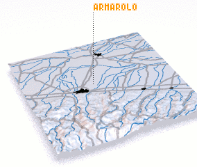 Places with similar names to Armarolo, Italy ::
// Armorel (US)
// Araemural-li (KP)
Disclaimer :: Information on this page comes without warranty of any kind |
||
|
Where is Armarolo? Elevation and coordinates ::
Latitude (lat): 44°36'0"N Longitude (lon): 11°28'0"E
Elevation (approx.): 13m (map arrows pan, magnifying glasses zoom) |
||
|
Visiting Armarolo? Hotel/Accommodation ::
Book a hotel in Armarolo Travel Guide ::
Buy a travel guide for Italy rental cars ::
car rental offers GPS waypoint ::
download a GPX waypoint (PoI) of Armarolo for your GPS receiver
|
||