|
search place name
|
||
Canneto Pavese (Italy)Canneto Pavese is a town in Italy. An overview map of the region around Canneto Pavese is displayed below.
regional and 3d topo map of Canneto Pavese, Italy ::

Canneto Pavese airports ::
The nearest airport is QPZ - Piacenza, located 37.9 km south east of Canneto Pavese.
Other airports nearby include LIN - Milan Linate (43.9 km north), BGY - Bergamo Orio Al Serio (76.8 km north east), MXP - Milano Malpensa (77.8 km north west), GOA - Genoa Genova Sestri (79.1 km south west), Nearby towns ::
Montu deʼ Gabbi (1.3km west) //
Broni (2.3km north west) //
Montii Beccaria (2.3km south east) //
Stradella (3.9km north) //
Montù Beccaria (3.2km south east) //
Campospinoso Albaredo (4.5km north west) //
Portalbera (4.5km north east) //
Michelazza (7.5km south) //
San Cipriano Po (7.5km north) //
Pietra deʼ Giorgi (6.4km south west) //
San Damiano al Colle (6.4km south east) //
Arena Po (6.4km north east) //
Valdamonte (7.9km south) //
San Zenone al Po (7.6km north east) //
[all distances 'as the bird flies' and approximate] 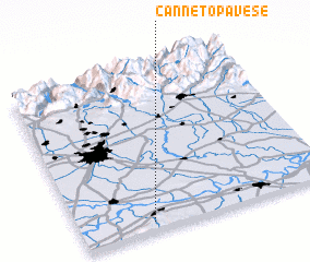 Places with similar names to Canneto Pavese, Italy :: Disclaimer :: Information on this page comes without warranty of any kind |
||
|
Where is Canneto Pavese? Elevation and coordinates ::
Latitude (lat): 45°3'0"N Longitude (lon): 9°17'0"E
Elevation (approx.): 198m (map arrows pan, magnifying glasses zoom) |
||
|
Visiting Canneto Pavese? Hotel/Accommodation ::
Book a hotel in Canneto Pavese Travel Guide ::
Buy a travel guide for Italy rental cars ::
car rental offers GPS waypoint ::
download a GPX waypoint (PoI) of Canneto Pavese for your GPS receiver
|
||