|
search place name
|
||
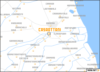
Casa Ottani (Italy)Casa Ottani is a town in Italy. An overview map of the region around Casa Ottani is displayed below.
regional and 3d topo map of Casa Ottani, Italy ::
Casa Ottani airports ::
The nearest airport is FRL - Forli, located 23.4 km south west of Casa Ottani.
Other airports nearby include RMI - Rimini (52.1 km south east), BLQ - Bologna (74.5 km west), FLR - Firenze (102.0 km south west), QPA - Padova (115.9 km north), Nearby towns ::
Villa Corradini (0.0km north) //
San Marco (1.9km south west) //
Molinaccio (2.3km south west) //
Classe Fuori (2.6km east) //
Ravenna (3.8km north) //
Ghibullo (5.8km south west) //
Vitalaccia (6.5km north east) //
Borgo Fosso Ghiaia (5.6km south east) //
San Vitale (7.0km north east) //
Porto Fuori (5.8km east) //
Casa San Vitale (7.9km north) //
Borgata Zarattini (6.5km north west) //
Gambellara (7.1km south west) //
Case del Bevano (7.7km south east) //
San Pietro in Vincoli (9.4km south west) //
[all distances 'as the bird flies' and approximate]  Places with similar names to Casa Ottani, Italy ::
Disclaimer :: Information on this page comes without warranty of any kind |
||
|
Where is Casa Ottani? Elevation and coordinates ::
Latitude (lat): 44°23'0"N Longitude (lon): 12°12'0"E
(map arrows pan, magnifying glasses zoom) |
||
|
Visiting Casa Ottani? Hotel/Accommodation ::
Book a hotel in Casa Ottani Travel Guide ::
Buy a travel guide for Italy rental cars ::
car rental offers GPS waypoint ::
download a GPX waypoint (PoI) of Casa Ottani for your GPS receiver
|
||