|
search place name
|
||
Cerlongo (Italy)Cerlongo is a town in Italy. An overview map of the region around Cerlongo is displayed below.
regional and 3d topo map of Cerlongo, Italy ::

Cerlongo airports ::
The nearest airport is VRN - Villafranca, located 23.6 km north east of Cerlongo.
Other airports nearby include VBS - Montichiari (28.7 km north west), PMF - Parma (57.5 km south west), VIC - Vicenza (77.2 km north east), QPZ - Piacenza (82.6 km south west), Nearby towns ::
Cereta (1.9km north) //
Volta Mantovana (3.9km north) //
Goito (4.5km south east) //
Guidizzolo (5.4km north west) //
Birbesi (5.2km west) //
Sacca (7.5km south) //
Ceresara (6.4km south west) //
Cavriana (7.9km north) //
[all distances 'as the bird flies' and approximate] 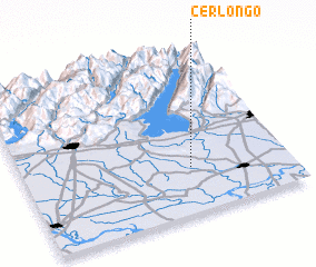 Places with similar names to Cerlongo, Italy ::
// Sarling (AT)
// Sierling (AT)
// Zeierling (AT)
// Sarling (DE)
// Zierling (DE)
// Serrallonga (ES)
// Sarlangā (IR)
// Serralongue (FR)
// Sêrlung (CN)
// Xarlung (CN)
Disclaimer :: Information on this page comes without warranty of any kind |
||
|
Where is Cerlongo? Elevation and coordinates ::
Latitude (lat): 45°17'0"N Longitude (lon): 10°38'0"E
Elevation (approx.): 44m (map arrows pan, magnifying glasses zoom) |
||
|
Visiting Cerlongo? Hotel/Accommodation ::
Book a hotel in Cerlongo Travel Guide ::
Buy a travel guide for Italy rental cars ::
car rental offers GPS waypoint ::
download a GPX waypoint (PoI) of Cerlongo for your GPS receiver
|
||