|
search place name
|
||
Champdepraz (Italy)Champdepraz is a town in Italy. An overview map of the region around Champdepraz is displayed below.
regional and 3d topo map of Champdepraz, Italy ::

Champdepraz airports ::
The nearest airport is TRN - Torino, located 53.6 km south of Champdepraz.
Other airports nearby include SIR - Sion (64.7 km north west), MXP - Milano Malpensa (84.2 km east), LUG - Lugano (104.2 km east), QNJ - Annemasse (121.1 km north west), Nearby towns ::
Chevrère (1.3km west) //
Fava (2.3km south east) //
Meran (2.3km north east) //
Fenillettaz (3.2km north east) //
Plout (3.9km north) //
Montjovet (3.9km north) //
Issogne (4.5km south east) //
Emarese (4.5km north east) //
Verrès (4.3km south east) //
Isola (4.3km north east) //
Saint-Vincent (7.4km north) //
Château (7.9km south) //
Châtillon (7.9km north) //
Chardonney (8.4km south west) //
Sommarese (7.6km north east) //
Prelaz (7.6km north west) //
Arnaz (7.6km south east) //
[all distances 'as the bird flies' and approximate] 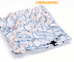 Places with similar names to Champdepraz, Italy :: Disclaimer :: Information on this page comes without warranty of any kind |
||
|
Where is Champdepraz? Elevation and coordinates ::
Latitude (lat): 45°41'0"N Longitude (lon): 7°39'0"E
Elevation (approx.): 663m (map arrows pan, magnifying glasses zoom) |
||
|
Visiting Champdepraz? Hotel/Accommodation ::
Book a hotel in Champdepraz Travel Guide ::
Buy a travel guide for Italy rental cars ::
car rental offers GPS waypoint ::
download a GPX waypoint (PoI) of Champdepraz for your GPS receiver
|
||