|
search place name
|
||
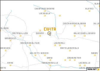
Civita (Italy)Civita is a town in Italy. An overview map of the region around Civita is displayed below.
regional and 3d topo map of Civita, Italy ::
Civita airports ::
The nearest airport is SUF - Lamezia Terme, located 101.3 km south of Civita.
Other airports nearby include CRV - Crotone (113.1 km south east), TAR - Grottaglie (122.0 km north east), BRI - Bari (151.9 km north), LCC - Lecce (163.4 km east), Nearby towns ::
Eianina (2.8km west) //
Frascineto (3.4km north west) //
Cassano al Ionio (4.0km south) //
Lauropoli (4.7km south east) //
La Casiola (7.5km north) //
Scorza (7.5km south) //
San Lorenzo Bellizzi (7.9km north) //
Masseria Salituri (6.8km south west) //
Ponte la Mennola (8.0km south east) //
Dolcetti (8.6km south west) //
[all distances 'as the bird flies' and approximate]  Places with similar names to Civita, Italy ::
Disclaimer :: Information on this page comes without warranty of any kind |
||
|
Where is Civita? Elevation and coordinates ::
Latitude (lat): 39°49'0"N Longitude (lon): 16°18'0"E
Elevation (approx.): 315m (map arrows pan, magnifying glasses zoom) |
||
|
Visiting Civita? Hotel/Accommodation ::
Book a hotel in Civita Travel Guide ::
Buy a travel guide for Italy rental cars ::
car rental offers GPS waypoint ::
download a GPX waypoint (PoI) of Civita for your GPS receiver
|
||