|
search place name
|
||
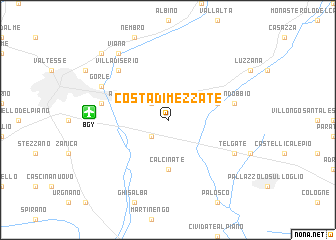
Costa di Mezzate (Italy)Costa di Mezzate is a town in Italy. An overview map of the region around Costa di Mezzate is displayed below.
regional and 3d topo map of Costa di Mezzate, Italy ::
Costa di Mezzate airports ::
The nearest airport is BGY - Bergamo Orio Al Serio, located 6.2 km west of Costa di Mezzate.
Other airports nearby include LIN - Milan Linate (46.6 km south west), VBS - Montichiari (50.2 km south east), LUG - Lugano (77.5 km north west), MXP - Milano Malpensa (82.4 km west), Nearby towns ::
Albano SantʼAlessandro (2.3km north west) //
Rocca del Colle (2.3km south west) //
Calcinate (5.6km south) //
Trescore Balneario (4.3km north east) //
Bergamo (5.5km west) //
Seriate (5.5km west) //
Zandobbio (5.5km east) //
Villa di Serio (6.8km north west) //
Gorle (6.4km north west) //
Telgate (6.4km south east) //
Viana (8.4km north west) //
Alzano di Sopra (8.4km north west) //
Alzano Lombardo (9.0km north west) //
[all distances 'as the bird flies' and approximate] 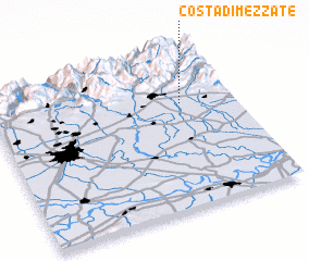 Places with similar names to Costa di Mezzate, Italy :: Disclaimer :: Information on this page comes without warranty of any kind |
||
|
Where is Costa di Mezzate? Elevation and coordinates ::
Latitude (lat): 45°40'0"N Longitude (lon): 9°47'0"E
Elevation (approx.): 236m (map arrows pan, magnifying glasses zoom) |
||
|
Visiting Costa di Mezzate? Hotel/Accommodation ::
Book a hotel in Costa di Mezzate Travel Guide ::
Buy a travel guide for Italy rental cars ::
car rental offers GPS waypoint ::
download a GPX waypoint (PoI) of Costa di Mezzate for your GPS receiver
|
||